Symbol

Sort condition
Newest first
Oldest first
Large number of views
  1. 富山サークルウォーク(富山県富山市)のGPSアート
    • Chubu RegionToyama
    • 31 - 50 km
    • Circle WalkLetter/Symbol/MapOfficialSymbol

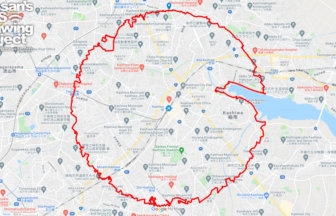
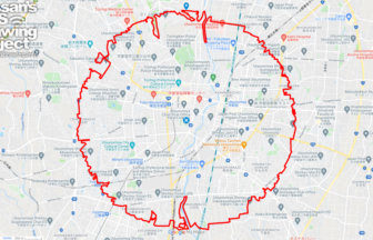
    Toyama Circle Walk 42km

    A circle with a radius of 3.14 km drawn around the circular fountain in the prefectural government park✨The prefectu…

  2. 金沢サークルウォーク(石川県金沢市)のGPSアート
    • Chubu RegionIshikawa
    • 31 - 50 km
    • Circle WalkLetter/Symbol/MapOfficialSymbol

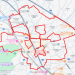
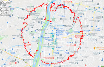
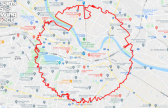
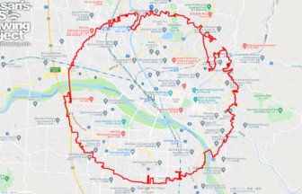
    Kanazawa Circle Walk 40km

    A circle with a radius of 3.14 km drawn around Kasumigaike in Kenrokuen Garden✨The course forms a circle with a radi…

  3. 新潟サークルウォーク(新潟県新潟市)
    • Chubu RegionNigata
    • 31 - 50 km
    • Circle WalkLetter/Symbol/MapOfficialSymbol

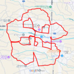
    Nigata Circle Walk 35km

    A circle with a radius of 3.14 km drawn in the urban area of Echigo✨Niigata City is the only ordinance-designated ci…

  4. 柏サークルウォーク(千葉県柏市)のGPSアート
    • ChibaKanto Region
    • 31 - 50 km
    • Circle WalkLetter/Symbol/MapOfficialSymbol

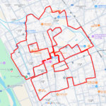
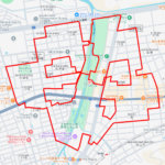
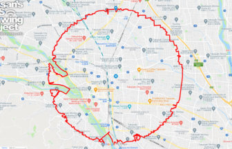
    Kashiwa Circle Walk 36km

    A circle with a radius of 3.14 km to be drawn around CHI-BA+KUN's nose✨Chiba Prefecture's official character "Chii-b…

  5. 水戸サークルウォーク(茨城県水戸市)のGPSアート
    • IbarakiKanto Region
    • 31 - 50 km
    • Circle WalkLetter/Symbol/MapOfficialSymbol

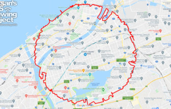
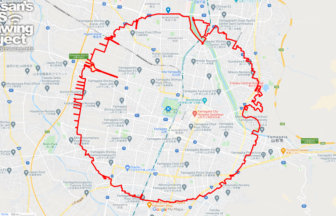
    Mito Circle Walk 43km

    A circle with a radius of 3.14 km drawn around Mito Castle✨Mito Castle was once home to one of the three Tokugawa fa…

  6. パリ サークルウォーク(パリ/フランス)のGPSアート
    • Europe
    • 31 - 50 km
    • Circle WalkLetter/Symbol/MapOfficialSymbol

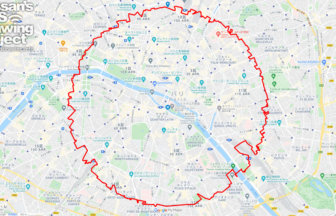
    Paris Circle Walk 33km

    The course of a circle with a radius of 3.14 km to be drawn at the 2024 Olympic venue✨After Tokyo, Paris! This is a…

  7. 高崎サークルウォーク(群馬県高崎市)のGPSアート
    • GunmaKanto Region
    • 31 - 50 km
    • Circle WalkLetter/Symbol/MapOfficialSymbol

    Takasaki Circle Walk 35km

    A circle with a radius of 3.14 km drawn at the gateway to the northern Kanto region✨Takasaki City is a major city in…

  8. Utsunomiya Circle Walk
    • Kanto RegionTochigi
    • 31 - 50 km
    • Circle WalkLetter/Symbol/MapOfficialSymbol

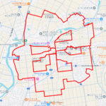
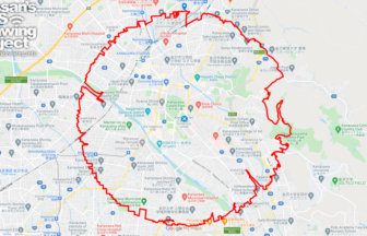
    Utsunomiya Circle Walk 40km

    A circle with a radius of 3.14 km drawn around the Utsunomiya castle ruins✨Utsunomiya City, an ordinance-designated …

  9. Morioka Circle Walk
    • IwateTohoku Region
    • 31 - 50 km
    • Circle WalkLetter/Symbol/MapOfficialSymbol

    Morioka Circle Walk 42km

    A circle of radius 3.14 km drawn in the Kitakami Basin✨Morioka City is located in the center of the Kitakami Basin i…

  10. Yamagata Circle Walk
    • Tohoku RegionYamagata
    • 31 - 50 km
    • Circle WalkLetter/Symbol/MapOfficialSymbol

    Yamagata Circle Walk 40km

    A circle with a radius of 3.14 km drawn in Yamagata Castle Town✨Yamagata Castle is located in the center of Yamagata…

  1. 勝山弁天桜のさくら(福井県勝山市)のGPSアート

    Cherry Blossom around Benten Ryokuchi, Katsuyama,…

  2. 妙了寺のさくら(山梨県南アルプス市)のGPSアート

    Cherry Blossom around Myoryo Temple, Minami-Alps,…

  3. 小諸城址のさくら(長野県小諸市)のGPSアート

    Cherry Blossom around Komoro Castle Ruins, Komoro…

  4. 平田公園のさくら(岐阜県海津市)のGPSアート

    Cherry Blossom around Hirata Park, Kaizu, Gifu pr…

  5. 平和市民公園のさくら(大分県大分市)のGPSアート

    Cherry Blossom in Heiwa City Park, Oita City 11km

  1. Douglas MacArthur in around Yokota Base 33km

  2. The squid is the symbol of Hakodate🦑, Hokkaido, …

  3. Aomori-Hakodate Ferry, Aomori, Aomori Pref. 11km

  4. E.T. flying through the sky, Kita Akita, Akita Pr…

  5. Nazca-style spider, Kita Akita, Akita Pref. 7.7km

ARCHIVES