Letter/Symbol/Map

Sort condition
Newest first
Oldest first
Large number of views
  1. 出雲サークルウォーク(島根県出雲市)のGPSアート
    • ShimaneChugoku Region
    • 21 - 30km
    • SymbolCircle WalkOfficialLetter/Symbol/Map

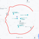
    Izumo Circle Walk 26km

    A circle with a radius of 3.14 km drawn on the plain in front of Izumo Taisha Shrine✨The course is a 3.14km radius ci…

  2. 岡山サークルウォーク(岡山県岡山市)のGPSアート
    • OkayamaChugoku Region
    • 31km - 50km
    • SymbolCircle WalkOfficialLetter/Symbol/Map

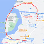
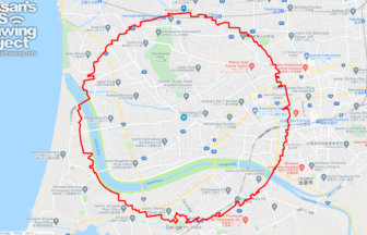
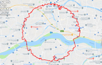
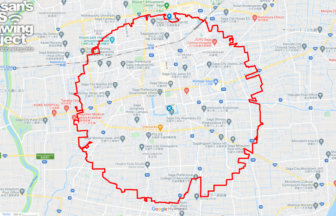
    Okayama Circle Walk 35km

    A circle with a radius of 3.14 km drawn on Okayama Castle✨Mt. So-zan, which was the center of the region in ancient t…

  3. 高松サークルウォーク(香川県高松市)のGPSアート
    • KagawaShikoku Island
    • 31km - 50km
    • SymbolCircle WalkOfficialLetter/Symbol/Map

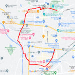
    Takamatsu Circle Walk 33km

    A circle with a radius of 3.14 km drawn at the gateway to Shikoku✨The course is a 3.14 km radius circle around Takama…

  4. 徳島サークルウォーク(徳島県徳島市)のGPSアート
    • TokushimaShikoku Island
    • 31km - 50km
    • SymbolCircle WalkOfficialLetter/Symbol/Map

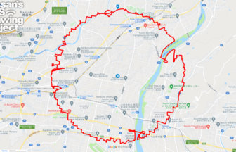
    Tokushima Circle Walk 37km

    A circle of radius 3.14 km drawn in the Yoshino River basin✨This circle walk is drawn in the basin of the Yoshino Riv…

  5. 松山サークルウォーク(愛媛県松山市)のGPSアート
    • EhimeShikoku Island
    • 31km - 50km
    • SymbolCircle WalkOfficialLetter/Symbol/Map

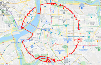
    Matsuyama Circle Walk 38km

    A circle with a radius of 3.14 km drawn in the castle town of Iyo-Matsuyama Castle✨Matsuyama City is the largest city…

  6. 高知サークルウォーク(高知県香美市)のGPSアート
    • KochiShikoku Island
    • 31km - 50km
    • SymbolCircle WalkOfficialLetter/Symbol/Map

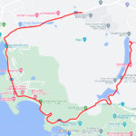
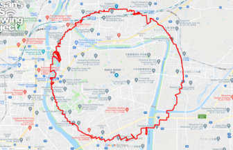
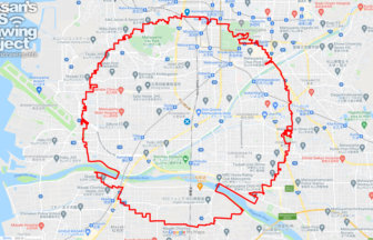
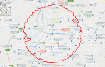
    Kochi Circle Walk 40km

    A circle of radius 3.14 km drawn on the Kochi Plain✨The Kochi Plain is an alluvial plain in southern Shikoku. The maj…

  7. 台北サークルウォーク(台北/台湾)のGPSアート
    • Asia
    • 31km - 50km
    • SymbolCircle WalkOfficialLetter/Symbol/Map

    Taipei Circle Walk 40km

    A circle with a radius of 3.14 km drawn around the center of Taiwan✨This is the origin of the Taiwan Highway, a road …

  8. 佐賀サークルウォーク(佐賀県佐賀市)のGPSアート
    • SagaKyushu & Okinawa Islands
    • 31km - 50km
    • SymbolCircle WalkOfficialLetter/Symbol/Map

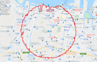
    Saga Circle Walk 39km

    A circle with a radius of 3.14 km drawn in the city of water✨The Saga Plain is one of the most important granary area…

  9. 船橋サークルウォーク(千葉県船橋市)のGPSアート
    • ChibaKanto Region
    • - 10km
    • SymbolCircle WalkOfficialLetter/Symbol/Map

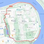
    Funabashi Circle Walk 2.6km

    A circle drawn on the site of a wireless telegraph station✨The Funabashi Transmitting Station of the Naval Wireless T…

  10. 都城サークルウォーク(宮崎県都城市)のGPSアート
    • MiyazakiKyushu & Okinawa Islands
    • 31km - 50km
    • SymbolCircle WalkOfficialLetter/Symbol/Map

    Miyakonojo Circle Walk 34km

    A circle with a radius of 3.14 km drawn at the birthplace of the Shimazu family✨Exactly 1,000 years ago, in the late …

  1. C(長崎県佐世保市)のGPSアート

    “C” in Sasebo, Nagasaki pref. 2km

  2. C(滋賀県草津市)のGPSアート

    “C” in Kusatsu, Shiga pref. 6km

  3. C(香川県直島町)のGPSアート

    “C” in Naoshima, Kagawa pref. 4km

  4. C(長野県長野市)のGPSアート

    “C” in Nagano City 5km

  5. C(東京都北区)のGPSアート

    “C” in Kita ward, Tokyo 1km

  1. Around the World in Osaka 20km

  2. 東京スカイツリーに描くこいのぼりのGPSアート

    Carp Streamer in around Tokyo Skytree 4km

  3. Cherry Blossom in Osaka Castle 9km

  4. Douglas MacArthur in around Yokota Base 33km

  5. ピースマーク(千葉県船橋市)のお絵かきラン

    PEACE on Finabashi, Chiba pref. 4km

ARCHIVES