Letter/Symbol/Map

Sort condition
Newest first
Oldest first
Large number of views
  1. 日田の太陽(大分県日田市)のGPSアート
    • OitaKyushu & Okinawa Islands
    • - 10km
    • SymbolSeasonLetter/Symbol/Map

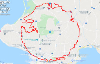
    The SUN in Hita, Oita pref. 8km

    GPS art of the sun drawn in the city of intense heat✨A course of GPS art of the "sun" draws in Hita City, Oita Prefec…

  2. 奈良サークルウォーク(奈良県奈良市)のGPSアート
    • NaraKinki Region
    • 31km - 50km
    • SymbolCircle WalkOfficialLetter/Symbol/Map

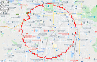
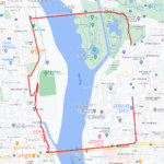
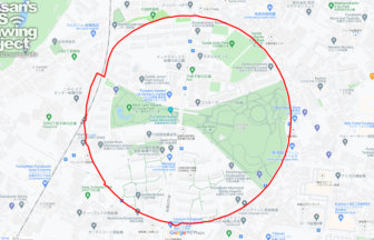
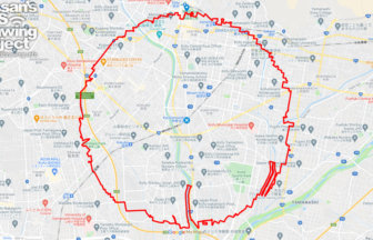
    Nara Circle Walk 32km

    A circle with a radius of 3.14 km drawn in Heijo-kyo✨Heijo-kyo, the center of the Nara period, a part of Japanese his…

  3. 石垣島サークルウォーク(沖縄県石垣市)38kmのGPSアート
    • Okinawa
    • 31km - 50km
    • SymbolCircle WalkOfficialLetter/Symbol/Map

    Ishigaki Circle Walk 38km

    Japan's Southernmost & Westernmost Circle Walk✨The course is a 3.14km radius circle around Ishigaki Island, the s…

  4. 船橋サークルウォーク(千葉県船橋市)のGPSアート
    • ChibaKanto Region
    • - 10km
    • SymbolCircle WalkOfficialLetter/Symbol/Map

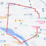
    Funabashi Circle Walk 2.6km

    A circle drawn on the site of a wireless telegraph station✨The Funabashi Transmitting Station of the Naval Wireless T…

  5. 四日市サークルウォーク(三重県四日市市)のGPSアート
    • MieKinki Region
    • 31km - 50km
    • SymbolCircle WalkOfficialLetter/Symbol/Map

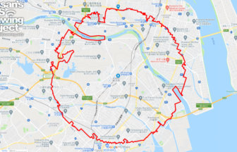
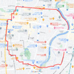
    Yokkaichi Circle Walk 37km

    A circle with a radius of 3.14 km drawn in a huge industrial area✨Yokkaichi City is an industrial city representing t…

  6. 那須温泉の”ゆ”(栃木県那須町)のGPSアート
    • TochigiKanto Region
    • 11 - 20km
    • LetterLandmarkLocal SpecialtiesLetter/Symbol/Map

    “ゆ (Hot Spring)” in Nasu T…

    GPS art of “YU” to be drawn in one of the most famous hot springs in Kanto Region♨✨A course of “ゆ (hotspring)” GPS a…

  7. 四万十の太陽(高知県四万十市)のGPSアート
    • KochiShikoku Island
    • - 10km
    • SymbolSeasonLetter/Symbol/Map

    The Sun in Shimanto, Kochi pref. 4km

    GPS art of the sun drawn in the city of intense heat✨A course of solar GPS art to be drawn in Shimanto City, Kochi Pr…

  8. 甲府サークルウォーク(山梨県甲府市)のGPSアート
    • YamanashiChubu Region
    • 31km - 50km
    • SymbolCircle WalkOfficialLetter/Symbol/Map

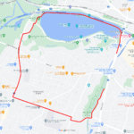
    Kofu Circle Walk 36km

    A circle with a radius of 3.14 km drawn in the lap of Takeda Shingen✨The Kofu Basin is a fan-shaped area located in t…

  9. 春日部の春(埼玉県春日部市)のGPSアート
    • SaitamaKanto Region
    • 11 - 20km
    • LetterSeasonLetter/Symbol/Map

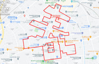
    春 (Spring) in Kasukabe, Saitama pref. …

    GPS calligraphy for "Spring" in Lichun✨February 4th is Lichun. This is the GPS art of "spring (春)" drawn in the name…

  10. 蔵王の”ゆ”(山形市蔵王温泉)のGPSアート
    • YamagataTohoku Region
    • - 10km
    • LetterLandmarkLocal SpecialtiesLetter/Symbol/Map

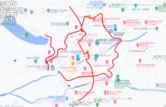
    “ゆ (Hot Spring)” in Zaō Ya…

    GPS art of “YU” to be drawn in one of the most famous hot springs in Japan♨✨A course of “ゆ (hotspring)” GPS art to d…

  1. C(群馬県前橋市)のGPSアート

    “C” in Maebashi, Gunma pref. 3km

  2. C(栃木県宇都宮市)のGPSアート

    “C” in Utsunomiya, Tochigi pref. 5km

  3. C(茨城県水戸市)のGPSアート

    “C” in Mito, Ibaraki pref. 5km

  4. C(福島県福島市)のGPSアート

    “C” in Fukushima City 3km

  5. C(山形県山形市)のGPSアート

    “C” in Yamagata City 5km

  1. 東京スカイツリーに描くこいのぼりのGPSアート

    Carp Streamer in around Tokyo Skytree 4km

  2. TokyoCircleWalk

    Tokyo Circle Walk 32km

  3. Douglas MacArthur in around Yokota Base 33km

  4. ピースマーク(千葉県船橋市)のお絵かきラン

    PEACE on Finabashi, Chiba pref. 4km

  5. 上野公園のさくら(東京都台東区)のGPSアート

    Cherry Blossom in Ueno Park, Tokyo 10km

ARCHIVES