Kanto Region
- Sort condition
- Newest first
- Oldest first
- Large number of views
-

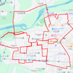
Snail in Kitamoto Nature Observation P…
Snail-Shaped GPS Art in Kitamoto Nature Observation Park is a vast green space dedicated to environmental conservatio…
-

Snail in Nagatoro California Poppy Gar…
GPS art of "snail" by traveling around Nagatoro California Poppy Garden and nearby countryside paths.
-

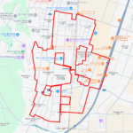
Frog between Oba River and Naka River,…
Frog-Shaped GPS Art in Togasaki, a tranquil riverside area nestled between the Oba River and the Nakagawa River.
-

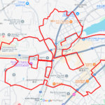
Frog on Toda Kyotei Boat Race, Toda, S…
Frog-Shaped GPS Art in Toda Boat Racecourse, the very first motorboat racing venue established in Japan.
-

Snail in Kyodo No Mori Historical Muse…
Enjoying Early Summer Strolls in Kyodo no Mori, an open-air museum nestled on the river terrace.
-

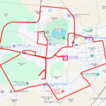
Snail in Asukayama Park, Kita Ward, To…
GPS art of a snail in a historic urban park beloved since the Edo period.
-

Snail in Wisteria and Hydrangea Road, …
Snail-Shaped GPS Art Along the Scenic Path of Wisteria and Hydrangeas.
-

“C” in Toda Park, Toda, Sa…
GPS art “C” onto the waterfront of a boat racecourse, a symbol of the city’s connection to water-based sports and rec…
-

“C” in Tama Lake, Higashiy…
"C"-Shaped GPS Art in nature around Lake Tama, an artificial lake created during the Taisho era.
-

“C” in Kasumigaura Bay, Ts…
“C”-Shaped GPS Art along the Western Shore of Lake Kasumigaura.