Symbol

Sort condition
Newest first
Oldest first
Large number of views
  1. 四万十の太陽(高知県四万十市)のGPSアート
    • KochiShikoku Island
    • - 10km
    • SymbolSeasonLetter/Symbol/Map

    The Sun in Shimanto, Kochi pref. 4km

    GPS art of the sun drawn in the city of intense heat✨A course of solar GPS art to be drawn in Shimanto City, Kochi Pr…

  2. 甲府サークルウォーク(山梨県甲府市)のGPSアート
    • YamanashiChubu Region
    • 31km - 50km
    • Circle WalkSymbolOfficialLetter/Symbol/Map

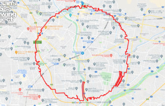
    Kofu Circle Walk 36km

    A circle with a radius of 3.14 km drawn in the lap of Takeda Shingen✨The Kofu Basin is a fan-shaped area located in t…

  3. 佐賀サークルウォーク(佐賀県佐賀市)のGPSアート
    • SagaKyushu & Okinawa Islands
    • 31km - 50km
    • Circle WalkSymbolOfficialLetter/Symbol/Map

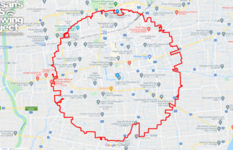
    Saga Circle Walk 39km

    A circle with a radius of 3.14 km drawn in the city of water✨The Saga Plain is one of the most important granary area…

  4. 金沢サークルウォーク(石川県金沢市)のGPSアート
    • IshikawaChubu Region
    • 31km - 50km
    • Circle WalkSymbolOfficialLetter/Symbol/Map

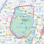
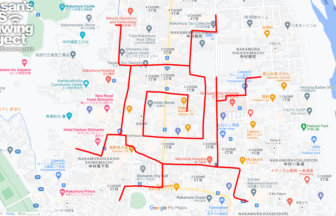
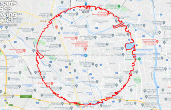
    Kanazawa Circle Walk 40km

    A circle with a radius of 3.14 km drawn around Kasumigaike in Kenrokuen Garden✨The course forms a circle with a radiu…

  5. 越谷サークルウォーク(埼玉県越谷市)のGPSアート
    • SaitamaKanto Region
    • 31km - 50km
    • Circle WalkSymbolOfficialLetter/Symbol/Map

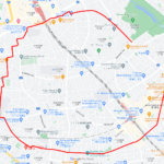
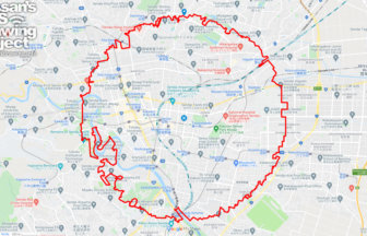
    Koshigaya Circle Walk 37km

    A circle with a radius of 3.14 km drawn around the Awa Odori statue✨Koshigaya City is one of the largest bedroom comm…

  6. Sendai Circle Walk
    • MiyagiTohoku Region
    • 31km - 50km
    • Circle WalkSymbolOfficialLetter/Symbol/Map

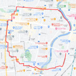
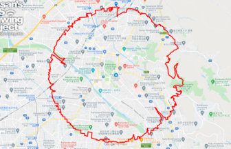
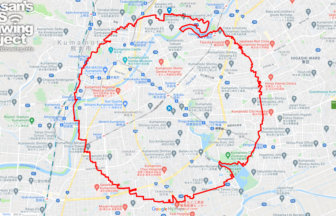
    Sendai Circle Walk 41km

    A circle with a radius of 3.14 km drawn in the castle town of Sendai✨This course is a circle drawn in the heart of To…

  7. 新潟サークルウォーク(新潟県新潟市)
    • NigataChubu Region
    • 31km - 50km
    • Circle WalkSymbolOfficialLetter/Symbol/Map

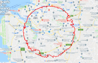
    Nigata Circle Walk 35km

    A circle with a radius of 3.14 km drawn in the urban area of Echigo✨Niigata City is the only ordinance-designated cit…

  8. 甲州の太陽(山梨県甲州市)のGPSアート
    • YamanashiChubu Region
    • 21 - 30km
    • SymbolSeasonLetter/Symbol/Map

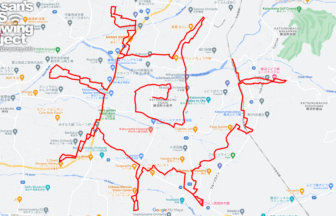
    The SUN in Koshu, Yamanashi pref. 27km…

    GPS art of the sun drawn in the city of intense heat✨A course of GPS art of the "sun" to be drawn in Koshu City, Yama…

  9. 熊本サークルウォーク(熊本県熊本市)のGPSアート
    • KumamotoKyushu & Okinawa Islands
    • 31km - 50km
    • Circle WalkSymbolOfficialLetter/Symbol/Map

    Kumamoto Circle Walk 35km

    A circle with a radius of 3.14km drawn under Kumamoto Castle✨Kumamoto City is one of the most important ordinance-des…

  10. 那覇サークルウォーク(沖縄県那覇市)のGPSアート
    • OkinawaKyushu & Okinawa Islands
    • 31km - 50km
    • Circle WalkSymbolOfficialLetter/Symbol/Map

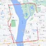
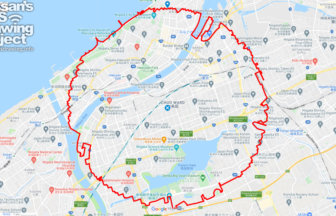
    Naha Circle Walk 39km

    A circle with a radius of 3.14 km drawn around the center of Okinawa Island✨This is a course that draws a perfect cir…

  1. C(東京都千代田区)のGPSアート

    “C” in Chiyoda ward, Tokyo 6km

  2. C(千葉県船橋市)のGPSアート

    “C” in Funabashi, Chiba pref. 2km

  3. C(埼玉県さいたま市)のGPSアート

    “C” in Saitama City 5km

  4. C(群馬県前橋市)のGPSアート

    “C” in Maebashi, Gunma pref. 3km

  5. C(栃木県宇都宮市)のGPSアート

    “C” in Utsunomiya, Tochigi pref. 5km

  1. 上野公園のさくら(東京都台東区)のGPSアート

    Cherry Blossom in Ueno Park, Tokyo 10km

  2. ミャクミャク様(大阪市)のGPSアート

    Myaku-Myaku in Osaka 41km

  3. 東京スカイツリーに描くこいのぼりのGPSアート

    Carp Streamer in around Tokyo Skytree 4km

  4. Cherry Blossom in Osaka Castle 9km

  5. TokyoCircleWalk

    Tokyo Circle Walk 32km

ARCHIVES