Official

Sort condition
Newest first
Oldest first
Large number of views
  1. 台北サークルウォーク(台北/台湾)のGPSアート
    • Asia
    • 31 - 50 km
    • Circle WalkLetter/Symbol/MapOfficialSymbol

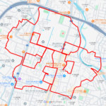
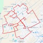
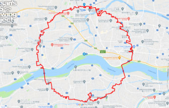
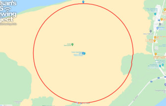
    Taipei Circle Walk 40km

    A circle with a radius of 3.14 km drawn around the center of Taiwan✨This is the origin of the Taiwan Highway, a road…

  2. 高知サークルウォーク(高知県香美市)のGPSアート
    • KochiShikoku Island
    • 31 - 50 km
    • Circle WalkLetter/Symbol/MapOfficialSymbol

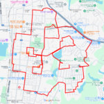
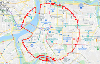
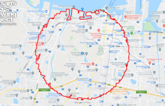
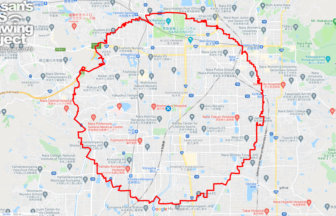
    Kochi Circle Walk 40km

    A circle of radius 3.14 km drawn on the Kochi Plain✨The Kochi Plain is an alluvial plain in southern Shikoku. The ma…

  3. 松山サークルウォーク(愛媛県松山市)のGPSアート
    • EhimeShikoku Island
    • 31 - 50 km
    • Circle WalkLetter/Symbol/MapOfficialSymbol

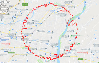
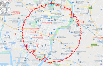
    Matsuyama Circle Walk 38km

    A circle with a radius of 3.14 km drawn in the castle town of Iyo-Matsuyama Castle✨Matsuyama City is the largest cit…

  4. 徳島サークルウォーク(徳島県徳島市)のGPSアート
    • Shikoku IslandTokushima
    • 31 - 50 km
    • Circle WalkLetter/Symbol/MapOfficialSymbol

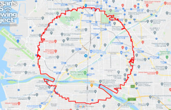
    Tokushima Circle Walk 37km

    A circle of radius 3.14 km drawn in the Yoshino River basin✨This circle walk is drawn in the basin of the Yoshino Ri…

  5. 高松サークルウォーク(香川県高松市)のGPSアート
    • KagawaShikoku Island
    • 31 - 50 km
    • Circle WalkLetter/Symbol/MapOfficialSymbol

    Takamatsu Circle Walk 33km

    A circle with a radius of 3.14 km drawn at the gateway to Shikoku✨The course is a 3.14 km radius circle around Takam…

  6. 岡山サークルウォーク(岡山県岡山市)のGPSアート
    • Chugoku RegionOkayama
    • 31 - 50 km
    • Circle WalkLetter/Symbol/MapOfficialSymbol

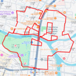
    Okayama Circle Walk 35km

    A circle with a radius of 3.14 km drawn on Okayama Castle✨Mt. So-zan, which was the center of the region in ancient …

  7. 出雲サークルウォーク(島根県出雲市)のGPSアート
    • Chugoku RegionShimane
    • 21 - 30 km
    • Circle WalkLetter/Symbol/MapOfficialSymbol

    Izumo Circle Walk 26km

    A circle with a radius of 3.14 km drawn on the plain in front of Izumo Taisha Shrine✨The course is a 3.14km radius c…

  8. 鳥取サークルウォーク(鳥取県鳥取市)のGPSアート
    • Chugoku RegionTottori
    • - 10 km
    • Circle WalkLetter/Symbol/MapOfficialSymbol

    Tottori Circle Walk 3.14km

    A 3.14km-long circle drawn on the Tottori Sand Dunes✨Isn't it a foul to draw freehand on an empty space? But here i…

  9. 奈良サークルウォーク(奈良県奈良市)のGPSアート
    • Kinki RegionNara
    • 31 - 50 km
    • Circle WalkLetter/Symbol/MapOfficialSymbol

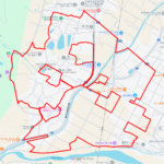
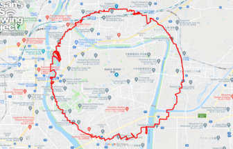
    Nara Circle Walk 32km

    A circle with a radius of 3.14 km drawn in Heijo-kyo✨Heijo-kyo, the center of the Nara period, a part of Japanese hi…

  10. 姫路サークルウォーク(兵庫県姫路市)のGPSアート
    • HyogoKinki Region
    • 31 - 50 km
    • Circle WalkLetter/Symbol/MapOfficialSymbol

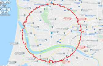
    Himeji Circle Walk 33km

    A circle with a radius of 3.14 km drawn on the World Heritage Site✨Himeji Castle, also known as Shirasagi-jo (White …

  1. ウインズ銀座の馬(東京都中央区)のGPSアート

    Horse around JRA Wins Ginza, Chuo, Tokyo 10km

  2. ウインズ津軽の馬(青森県田舎館村)のGPSアート

    Horse around JRA Wins Tsugaru, Inakadate, Aomori …

  3. ウインズ立川の馬(東京都立川市)のGPSアート

    Horse around JRA Wins Tachikawa,Tachikawa, Tokyo …

  4. ウインズ札幌の馬(北海道札幌市中央区)のGPSアート

    Horse around JRA Wins Sapporo, Sapporo, Hokkaido …

  5. ウインズ後楽園の馬(東京都文京区)のGPSアート

    Horse around JRA Wins Korakuen, Tokyo 19km

  1. Cherry Blossom in around Nago Castle Park 16km

  2. TokyoCircleWalk

    Tokyo Circle Walk 32km

  3. Cherry Blossom in Osaka Castle 9km

  4. ピースマーク(千葉県船橋市)のお絵かきラン

    PEACE on Finabashi, Chiba pref. 4km

  5. The squid is the symbol of Hakodate🦑, Hokkaido, …

ARCHIVES