31 - 50 km

Sort condition
Newest first
Oldest first
Large number of views
  1. 高知サークルウォーク(高知県香美市)のGPSアート
    • KochiShikoku Island
    • 31 - 50 km
    • Circle WalkLetter/Symbol/MapOfficialSymbol

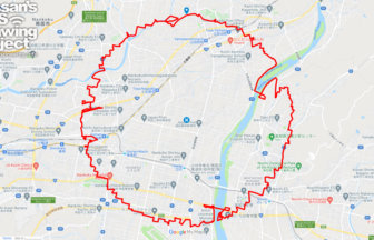
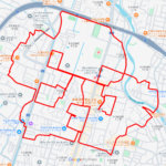
    Kochi Circle Walk 40km

    A circle of radius 3.14 km drawn on the Kochi Plain✨The Kochi Plain is an alluvial plain in southern Shikoku. The ma…

  2. 松山サークルウォーク(愛媛県松山市)のGPSアート
    • EhimeShikoku Island
    • 31 - 50 km
    • Circle WalkLetter/Symbol/MapOfficialSymbol

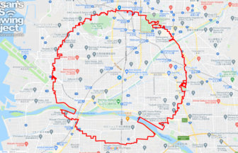
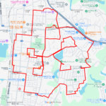
    Matsuyama Circle Walk 38km

    A circle with a radius of 3.14 km drawn in the castle town of Iyo-Matsuyama Castle✨Matsuyama City is the largest cit…

  3. 徳島サークルウォーク(徳島県徳島市)のGPSアート
    • Shikoku IslandTokushima
    • 31 - 50 km
    • Circle WalkLetter/Symbol/MapOfficialSymbol

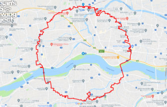
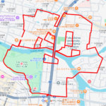
    Tokushima Circle Walk 37km

    A circle of radius 3.14 km drawn in the Yoshino River basin✨This circle walk is drawn in the basin of the Yoshino Ri…

  4. 高松サークルウォーク(香川県高松市)のGPSアート
    • KagawaShikoku Island
    • 31 - 50 km
    • Circle WalkLetter/Symbol/MapOfficialSymbol

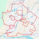
    Takamatsu Circle Walk 33km

    A circle with a radius of 3.14 km drawn at the gateway to Shikoku✨The course is a 3.14 km radius circle around Takam…

  5. 岡山サークルウォーク(岡山県岡山市)のGPSアート
    • Chugoku RegionOkayama
    • 31 - 50 km
    • Circle WalkLetter/Symbol/MapOfficialSymbol

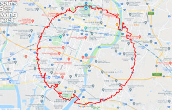
    Okayama Circle Walk 35km

    A circle with a radius of 3.14 km drawn on Okayama Castle✨Mt. So-zan, which was the center of the region in ancient …

  6. 奈良サークルウォーク(奈良県奈良市)のGPSアート
    • Kinki RegionNara
    • 31 - 50 km
    • Circle WalkLetter/Symbol/MapOfficialSymbol

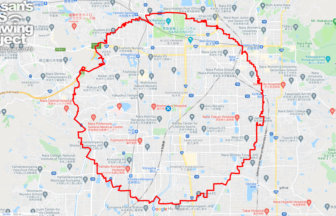
    Nara Circle Walk 32km

    A circle with a radius of 3.14 km drawn in Heijo-kyo✨Heijo-kyo, the center of the Nara period, a part of Japanese hi…

  7. 姫路サークルウォーク(兵庫県姫路市)のGPSアート
    • HyogoKinki Region
    • 31 - 50 km
    • Circle WalkLetter/Symbol/MapOfficialSymbol

    Himeji Circle Walk 33km

    A circle with a radius of 3.14 km drawn on the World Heritage Site✨Himeji Castle, also known as Shirasagi-jo (White …

  8. 大阪サークルウォーク(大阪府大阪市)のGPSアート
    • Kinki RegionOsaka
    • 31 - 50 km
    • Circle WalkLetter/Symbol/MapOfficialSymbol

    Osaksa Circle Walk 33km

    A circle with a radius of 3.14 km drawn around the Osaka Castle tower✨Osaka Castle, built in the Azuchi-Momoyama per…

  9. マドリッド サークルウォーク(マドリッド/スペイン)のGPSアート
    • Europe
    • 31 - 50 km
    • Circle WalkLetter/Symbol/MapOfficialSymbol

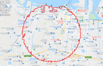
    Madrid Circle Walk 38km

    A circular course with a radius of 3.14 km drawn in the center of Spain✨Kilómetro Cero is a road marker that serves …

  10. 四日市サークルウォーク(三重県四日市市)のGPSアート
    • Kinki RegionMie
    • 31 - 50 km
    • Circle WalkLetter/Symbol/MapOfficialSymbol

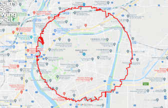
    Yokkaichi Circle Walk 37km

    A circle with a radius of 3.14 km drawn in a huge industrial area✨Yokkaichi City is an industrial city representing …

  1. 造幣局広島支局のさくら(広島県広島市佐伯区)のGPSアート

    Cherry Blossom around Japan MINT Hiroshimashi Bur…

  2. 若山公園のさくら(山口県山陽小野田市)のGPSアート

    Cherry Blossom around Wakayama Park, Sanyoonoda, …

  3. 徳島中央公園のさくら(徳島県徳島市)のGPSアート

    Cherry Blossom in Tokushima Central Park, Tokushi…

  4. 不動の滝カントリーパークのさくら(香川県三豊市)のGPSアート

    Cherry Blossom near Country Park, Mitoyo, Kagawa …

  5. 西山興隆寺のさくら(愛媛県西条市)のGPSアート

    Cherry Blossom near Koryu Temple, Saijo, Ehime pr…

  1. Cherry Blossom in around Nago Castle Park 16km

  2. TokyoCircleWalk

    Tokyo Circle Walk 32km

  3. Nazca-style spider, Kita Akita, Akita Pref. 7.7km

  4. From the Athletic Field #PEACE, Akita, Akita Pref…

  5. E.T. flying through the sky, Kita Akita, Akita Pr…

ARCHIVES