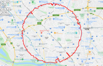
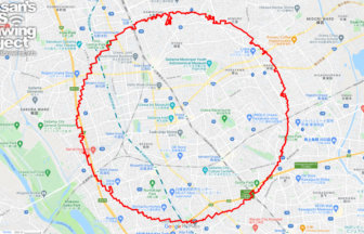
31km - 50km

Sort condition
Newest first
Oldest first
Large number of views
  1. 蕨サークルウォーク(埼玉県蕨市)蕨サークルウォーク(埼玉県蕨市)のGPSアート
    • SaitamaKanto Region
    • 31km - 50km
    • Circle WalkSymbolOfficialLetter/Symbol/Map

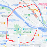
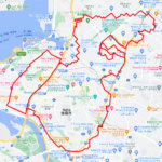
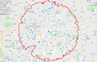
    Warabi Circle Walk 33km

    Circle walk GPS Drawing with a radius of 3.14 km drawn around Warabi Station✨This is an additional course proposal fo…

  2. 浦和サークルウォーク(埼玉県さいたま市)のGPSアート
    • SaitamaKanto Region
    • 31km - 50km
    • Circle WalkSymbolOfficialLetter/Symbol/Map

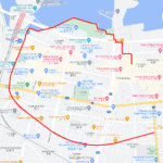
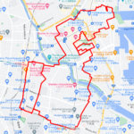
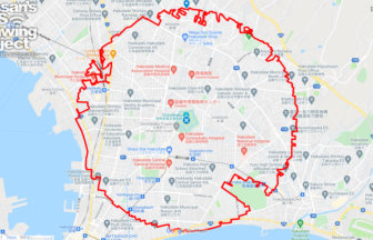
    Urawa Circle Walk 32km

    Circle walk with a radius of 3.14km drawn around Urawa Unako-chan✨This is an additional course plan for the approachi…

  3. 千代保稲荷神社の虎(岐阜県海津市)のGPSアート
    • GifuChubu Region
    • 31km - 50km
    • New YearAnimalTigerSeasonAnimal/PlantZodiac Animal

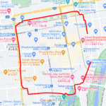
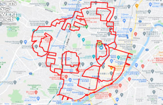
    Tiger in Chiyoho Inari Shrine, Kaizu C…

    GPS art of a tiger drawn on "Ochobo-san" for business prosperity and family safety✨This is a course of GPS art of the…

  4. 加藤神社の虎(熊本県熊本市)のGPSアート
    • KumamotoKyushu & Okinawa Islands
    • 31km - 50km
    • New YearAnimalTigerSeasonAnimal/PlantZodiac Animal

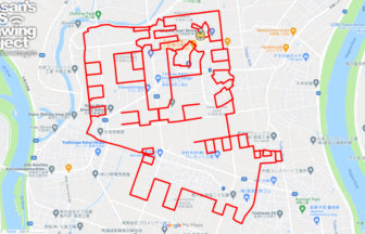
    Tiger in Kato Shrine, Kumamoto City, K…

    GPS Art of Chinese Zodiac Signs drawn on a Tiger Shrine✨The Kato Shrine enshrines Kiyomasa Kato, a warlord from the A…

  5. 鉄(愛知県東海市)のGPSアート
    • AichiChubu Region
    • 31km - 50km
    • LetterLetter/Symbol/Map

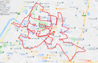
    鉄 (Iron) in Shuurakuen, Tokai, Aichi p…

    GPS art of "IRON" drawn in the city of iron✨Tokai City is a town of steel mills located between the Chita Peninsula a…

  6. 石垣島サークルウォーク(沖縄県石垣市)38kmのGPSアート
    • Okinawa
    • 31km - 50km
    • SymbolCircle WalkOfficialLetter/Symbol/Map

    Ishigaki Circle Walk 38km

    Japan's Southernmost & Westernmost Circle Walk✨The course is a 3.14km radius circle around Ishigaki Island, the s…

  7. ブリュッセル サークルウォーク(ブリュッセル/ベルギー)のGPSアート
    • Europe
    • 31km - 50km
    • SymbolCircle WalkOfficialLetter/Symbol/Map

    Brusselles Circle Walk 35km

    A perfect circle of radius 3.14 km drawn around the center point of Belgium✨In the center of the courtyard of the Bel…

  8. 函館サークルウォーク(北海道函館市)のGPSアート
    • Hokkaido
    • 31km - 50km
    • SymbolCircle WalkOfficialLetter/Symbol/Map

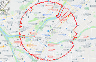
    Hakodate Circle Walk 33km

    The course of an equilateral circle drawn around Goryokaku✨Goryokaku was Japan's first Western-style fortress. It was…

  9. 旭川サークルウォーク(北海道旭川市)のGPSアート
    • Hokkaido
    • 31km - 50km
    • SymbolCircle WalkOfficialLetter/Symbol/Map

    Asahikawa Circle Walk 38km

    A circle with a radius of 3.14 km drawn in the central city of Hokkaido✨Located in the center of Hokkaido, Asahikawa …

  10. 那覇サークルウォーク(沖縄県那覇市)のGPSアート
    • OkinawaKyushu & Okinawa Islands
    • 31km - 50km
    • SymbolCircle WalkOfficialLetter/Symbol/Map

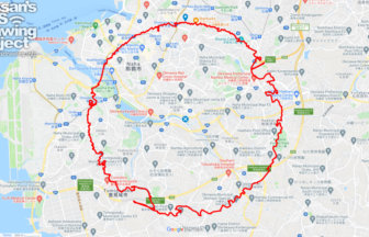
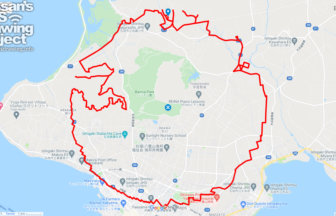
    Naha Circle Walk 39km

    A circle with a radius of 3.14 km drawn around the center of Okinawa Island✨This is a course that draws a perfect cir…

  1. C(岩手県盛岡市)のGPSアート

    “C” in Morioka, Iwate pref. 5km

  2. C(青森県青森市)のGPSアート

    “C” in Aomori City 11km

  3. C(北海道札幌市)のGPSアート

    “C” in Sapporo, Hokkaido 5km

  4. がんばろう能登(沖縄県那覇市)のGPSアート

    Ganbaro Noto in Naha 20km

  5. がんばろう能登(鹿児島県鹿児島市)のGPSアート

    Ganbaro Noto in Kagoshima 13km

  1. 上野公園のさくら(東京都台東区)のGPSアート

    Cherry Blossom in Ueno Park, Tokyo 10km

  2. 東京スカイツリーに描くこいのぼりのGPSアート

    Carp Streamer in around Tokyo Skytree 4km

  3. Cherry Blossom in Osaka Castle 9km

  4. Douglas MacArthur in around Yokota Base 33km

  5. Cherry Blossom in around Nago Castle Park 16km

ARCHIVES