Shikoku Island

Sort condition
Newest first
Oldest first
Large number of views
  1. 桜づつみ公園のさくら(高知県香南市)のGPSアート
    • KochiShikoku Island
    • - 10km
    • PlantCherry BlossomSeasonAnimal/Plant

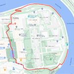
    Cherry Blossom in Sakurazutsumi Park, …

    Spring's First One Step Ahead! GPS art of cherry blossoms✨This course allows you to draw GPS art of cherry blossoms …

  2. 父養寺に描くカタツムリのお絵かきラン
    • KochiShikoku Island
    • - 10km
    • AnimalRainy SeasonSeasonAnimal/Plant

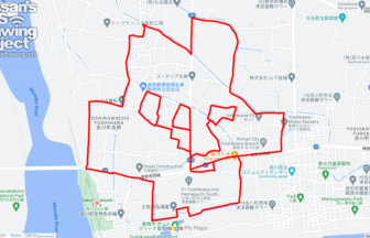
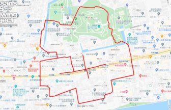
    Snail in Buyōji in Konan City, Kochi p…

    Course on Snails in Hydrangea Spots Introduced by Matsuko🐌✨The "Noichi Hydrangea Road" at Buyōji has 19,000 hydrangea…

  3. 勝名寺に描くカタツムリのGPSアート
    • KagawaShikoku Island
    • 21 - 30km
    • AnimalRainy SeasonSeasonAnimal/Plant

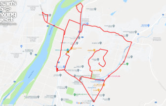
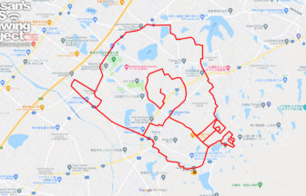
    Snail in around Shomyo Temple in Takam…

    Snails drawn at one of Kagawa's most famous hydrangea spots🐌✨Shomyoji Temple, a hydrangea spot in Takamatsu City, Kag…

    • KochiShikoku Island
    • - 10km
    • PlantCherry BlossomSeasonAnimal/Plant

    Cherry Blossom in around Kōchi Park, K…

    A course of GPS art of cherry blossoms that includes a tour of the grounds of Kochi Castle.🌸Kochi Castle has been sel…

  4. 粟井神社に描くカタツムリのGPSアート
    • KagawaShikoku Island
    • 11 - 20km
    • AnimalRainy SeasonSeasonAnimal/Plant

    Snail in around Awai Shrine in Kanonji…

    A Course to Visit the Most Representative Hydrangea Temples in Kagawa Prefecture🐌✨The shrine has such a long history …

  5. 高松サークルウォーク(香川県高松市)のGPSアート
    • KagawaShikoku Island
    • 31km - 50km
    • Circle WalkSymbolOfficialLetter/Symbol/Map

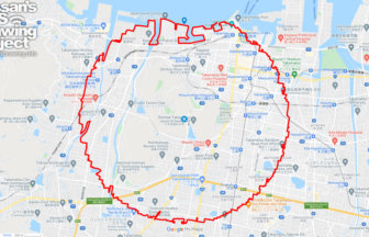
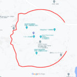
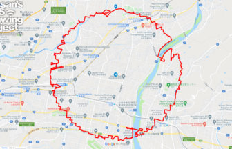
    Takamatsu Circle Walk 33km

    A circle with a radius of 3.14 km drawn at the gateway to Shikoku✨The course is a 3.14 km radius circle around Takama…

  6. 松山サークルウォーク(愛媛県松山市)のGPSアート
    • EhimeShikoku Island
    • 31km - 50km
    • Circle WalkSymbolOfficialLetter/Symbol/Map

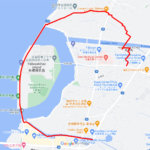
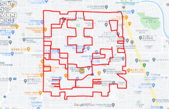
    Matsuyama Circle Walk 38km

    A circle with a radius of 3.14 km drawn in the castle town of Iyo-Matsuyama Castle✨Matsuyama City is the largest city…

  7. 高知サークルウォーク(高知県香美市)のGPSアート
    • KochiShikoku Island
    • 31km - 50km
    • Circle WalkSymbolOfficialLetter/Symbol/Map

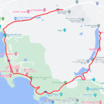
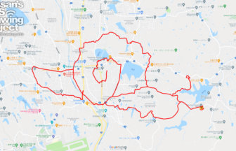
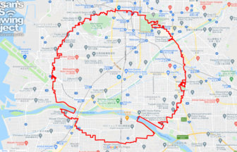
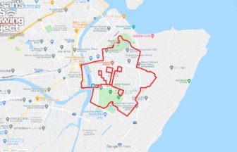
    Kochi Circle Walk 40km

    A circle of radius 3.14 km drawn on the Kochi Plain✨The Kochi Plain is an alluvial plain in southern Shikoku. The maj…

  8. 伊豫豆比古命神社の虎(愛媛県松山市)のGPSアート
    • EhimeShikoku Island
    • 11 - 20km
    • AnimalTigerAnimal/PlantZodiac Animal

    Tiger in Tsubaki-jinja Shrine, Matsuya…

    GPS art of a tiger drawn on a shrine that has been around for over 2300 years✨Iyozuhikonomikoto Shrine, located in Ma…

    • TokushimaShikoku Island
    • - 10km
    • PlantCherry BlossomSeasonAnimal/Plant

    Cherry Blossom in around Myōkensan Par…

    A GPS art course that takes you on a hike through a cherry blossom viewing spot where the entire mountain is colored …

  1. C(長崎県佐世保市)のGPSアート

    “C” in Sasebo, Nagasaki pref. 2km

  2. C(滋賀県草津市)のGPSアート

    “C” in Kusatsu, Shiga pref. 6km

  3. C(香川県直島町)のGPSアート

    “C” in Naoshima, Kagawa pref. 4km

  4. C(長野県長野市)のGPSアート

    “C” in Nagano City 5km

  5. C(東京都北区)のGPSアート

    “C” in Kita ward, Tokyo 1km

  1. TokyoCircleWalk

    Tokyo Circle Walk 32km

  2. 東京スカイツリーに描くこいのぼりのGPSアート

    Carp Streamer in around Tokyo Skytree 4km

  3. Cherry Blossom in Osaka Castle 9km

  4. Cherry Blossom in around Nago Castle Park 16km

  5. ミャクミャク様(大阪市)のGPSアート

    Myaku-Myaku in Osaka 41km

ARCHIVES