Symbol

Sort condition
Newest first
Oldest first
Large number of views
  1. 富山サークルウォーク(富山県富山市)のGPSアート
    • ToyamaChubu Region
    • 31km - 50km
    • SymbolCircle WalkOfficialLetter/Symbol/Map

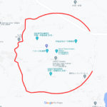
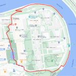
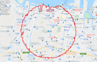
    Toyama Circle Walk 42km

    A circle with a radius of 3.14 km drawn around the circular fountain in the prefectural government park✨The prefectur…

  2. 水戸サークルウォーク(茨城県水戸市)のGPSアート
    • IbarakiKanto Region
    • 31km - 50km
    • SymbolCircle WalkOfficialLetter/Symbol/Map

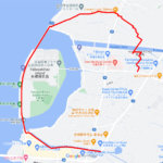
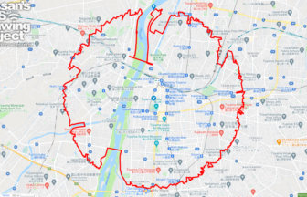
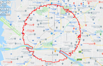
    Mito Circle Walk 43km

    A circle with a radius of 3.14 km drawn around Mito Castle✨Mito Castle was once home to one of the three Tokugawa fam…

  3. 札幌サークルウォーク(札幌市)
    • Hokkaido
    • 31km - 50km
    • SymbolCircle WalkOfficialLetter/Symbol/Map

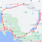
    Sapporo Circle Walk 34km

    A circle with a radius of 3.14 km drawn around the Sapporo TV Tower✨The Sapporo TV Tower was built in 1956 at the daw…

  4. 浜松の太陽(静岡県浜松市)のGPSアート
    • ShizuokaChubu Region
    • 11 - 20km
    • SymbolSeasonLetter/Symbol/Map

    The SUN in Hamamatsu, Shizuoka pref. 1…

    GPS art of the sun drawn in the city of intense heat✨A course of GPS art of the "sun" to be drawn in Hamamatsu City, …

  5. Utsunomiya Circle Walk
    • TochigiKanto Region
    • 31km - 50km
    • SymbolCircle WalkOfficialLetter/Symbol/Map

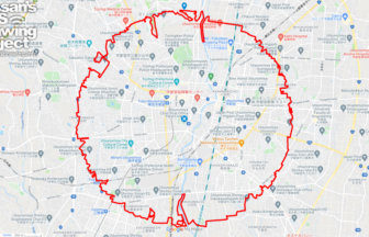
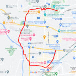
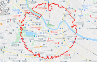
    Utsunomiya Circle Walk 40km

    A circle with a radius of 3.14 km drawn around the Utsunomiya castle ruins✨Utsunomiya City, an ordinance-designated c…

  6. 日比谷公園のト音記号(東京都千代田区)のGPSアート
    • TokyoKanto Region
    • - 10km
    • SymbolLetter/Symbol/Map

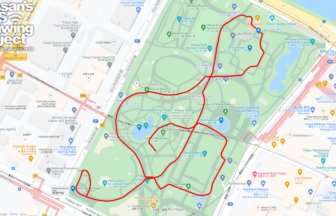
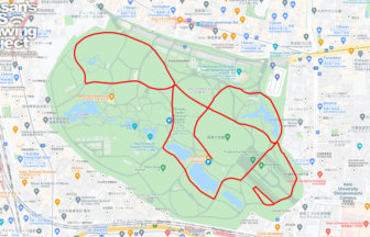
    G clef in Hibiya Park, Tokyo 2km

    GPS art of drawing a G clef in the middle of Tokyo✨This is a GPS art course where you can draw a G clef in Hibiya Par…

  7. 大宮サークルウォーク(埼玉県さいたま市)のGPSアート
    • SaitamaKanto Region
    • 31km - 50km
    • SymbolCircle WalkOfficialLetter/Symbol/Map

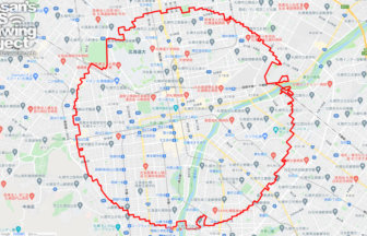
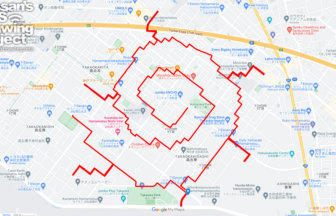
    Omiya Circle Walk 32km

    Circle with a radius of 3.14 km drawn around Omiya Station✨Omiya Station is one of the major terminals in Saitama Pre…

  8. 高松サークルウォーク(香川県高松市)のGPSアート
    • KagawaShikoku Island
    • 31km - 50km
    • SymbolCircle WalkOfficialLetter/Symbol/Map

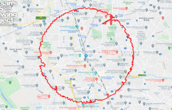
    Takamatsu Circle Walk 33km

    A circle with a radius of 3.14 km drawn at the gateway to Shikoku✨The course is a 3.14 km radius circle around Takama…

  9. 新宿御苑のト音記号(東京都新宿区)のGPSアート
    • TokyoKanto Region
    • - 10km
    • SymbolLetter/Symbol/Map

    G clef in Shinjuku Gyoen, Tokyo 2km

    GPS art that can be drawn without densification in the middle of the city✨This course uses the entire Shinjuku Gyoen …

  10. 松山サークルウォーク(愛媛県松山市)のGPSアート
    • EhimeShikoku Island
    • 31km - 50km
    • SymbolCircle WalkOfficialLetter/Symbol/Map

    Matsuyama Circle Walk 38km

    A circle with a radius of 3.14 km drawn in the castle town of Iyo-Matsuyama Castle✨Matsuyama City is the largest city…

  1. C(長崎県佐世保市)のGPSアート

    “C” in Sasebo, Nagasaki pref. 2km

  2. C(滋賀県草津市)のGPSアート

    “C” in Kusatsu, Shiga pref. 6km

  3. C(香川県直島町)のGPSアート

    “C” in Naoshima, Kagawa pref. 4km

  4. C(長野県長野市)のGPSアート

    “C” in Nagano City 5km

  5. C(東京都北区)のGPSアート

    “C” in Kita ward, Tokyo 1km

  1. 東京スカイツリーに描くこいのぼりのGPSアート

    Carp Streamer in around Tokyo Skytree 4km

  2. Douglas MacArthur in around Yokota Base 33km

  3. Around the World in Osaka 20km

  4. 上野公園のさくら(東京都台東区)のGPSアート

    Cherry Blossom in Ueno Park, Tokyo 10km

  5. Cherry Blossom in around Nago Castle Park 16km

ARCHIVES