Letter/Symbol/Map

Sort condition
Newest first
Oldest first
Large number of views
  1. 台北サークルウォーク(台北/台湾)のGPSアート
    • Asia
    • 31km - 50km
    • SymbolCircle WalkOfficialLetter/Symbol/Map

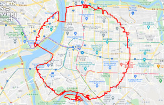
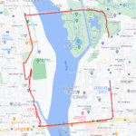
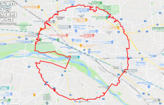
    Taipei Circle Walk 40km

    A circle with a radius of 3.14 km drawn around the center of Taiwan✨This is the origin of the Taiwan Highway, a road …

  2. 浜松サークルウォーク(静岡県浜松市)のGPSアート
    • ShizuokaChubu Region
    • 31km - 50km
    • SymbolCircle WalkOfficialLetter/Symbol/Map

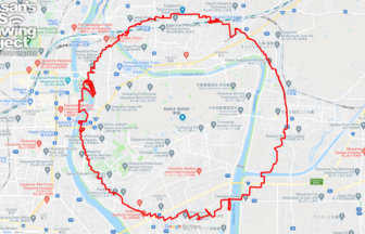
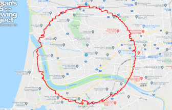
    Hamamatsu Circle Walk 33km

    A circle with a radius of 3.14 km drawn around the castle tower of Hamamatsu Castle✨Hamamatsu Castle is known as the …

  3. ピースマーク(千葉県船橋市)のお絵かきラン
    • ChibaKanto Region
    • - 10km
    • SymbolLetter/Symbol/Map

    PEACE on Finabashi, Chiba pref. 4km

    GPS art of peace marks drawn on war heritage✨Run and walk for PEACE! This is a course where you can use GPS art to d…

  4. 熊谷サークルウォーク(埼玉県熊谷市)のGPSアート
    • SaitamaKanto Region
    • 31km - 50km
    • SymbolCircle WalkOfficialLetter/Symbol/Map

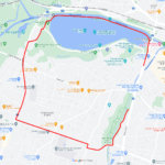
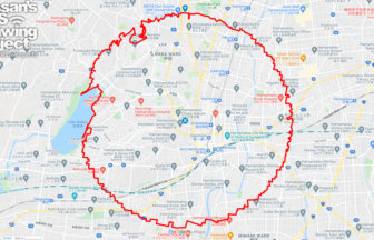
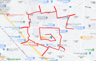
    Kumagaya Circle Walk 36km

    Circle walk with a radius of 3.14 km, drawn in the center of northern Saitama✨As Saitama residents will understand, ……

  5. 岡山サークルウォーク(岡山県岡山市)のGPSアート
    • OkayamaChugoku Region
    • 31km - 50km
    • SymbolCircle WalkOfficialLetter/Symbol/Map

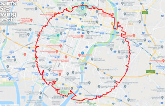
    Okayama Circle Walk 35km

    A circle with a radius of 3.14 km drawn on Okayama Castle✨Mt. So-zan, which was the center of the region in ancient t…

  6. 姫路サークルウォーク(兵庫県姫路市)のGPSアート
    • HyogoKinki Region
    • 31km - 50km
    • SymbolCircle WalkOfficialLetter/Symbol/Map

    Himeji Circle Walk 33km

    A circle with a radius of 3.14 km drawn on the World Heritage Site✨Himeji Castle, also known as Shirasagi-jo (White E…

  7. 熊谷の太陽(埼玉県熊谷市)のGPSアート
    • Saitama
    • - 10km
    • SymbolSeasonLetter/Symbol/Map

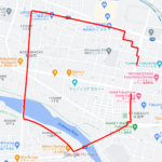
    The Sun in Kumagaya, Saitama pref. 6km…

    GPS art of the sun drawing in the land of the highest temperatures✨A course of GPS art of the sun, drawn in Kumagaya …

  8. ツーハンド-レッズ(百人町)のGPSアート
    • TokyoKanto Region
    • 11 - 20km
    • LetterLetter/Symbol/Map

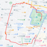
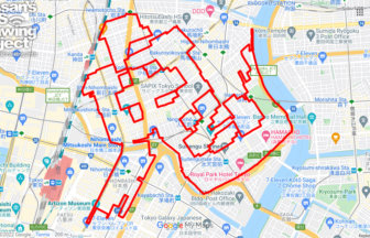
    Two Hand-Reds in Hyakunin-cho 12km

    200" GPS art to be drawn in Shinjuku Hyakunin-cho✨.✨This is a course of GPS art to be drawn in Shinjuku Hyakunin-cho.…

  9. 出雲サークルウォーク(島根県出雲市)のGPSアート
    • ShimaneChugoku Region
    • 21 - 30km
    • SymbolCircle WalkOfficialLetter/Symbol/Map

    Izumo Circle Walk 26km

    A circle with a radius of 3.14 km drawn on the plain in front of Izumo Taisha Shrine✨The course is a 3.14km radius ci…

  10. 日本橋の鬼(東京都中央区)のGPSアート
    • TokyoKanto Region
    • 11 - 20km
    • LetterOni (Japanese Damon)Letter/Symbol/Map

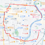
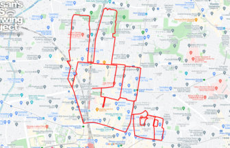
    Oni (鬼) in Nihonbashi, Tokyo 19km

    Super hard! GPS art of "Oni (鬼)" with many turns.✨The perfect "demon (Oni: 鬼)" for Setsubun…… designed a super diff…

  1. C(群馬県前橋市)のGPSアート

    “C” in Maebashi, Gunma pref. 3km

  2. C(栃木県宇都宮市)のGPSアート

    “C” in Utsunomiya, Tochigi pref. 5km

  3. C(茨城県水戸市)のGPSアート

    “C” in Mito, Ibaraki pref. 5km

  4. C(福島県福島市)のGPSアート

    “C” in Fukushima City 3km

  5. C(山形県山形市)のGPSアート

    “C” in Yamagata City 5km

  1. Douglas MacArthur in around Yokota Base 33km

  2. Cherry Blossom in around Nago Castle Park 16km

  3. 上野公園のさくら(東京都台東区)のGPSアート

    Cherry Blossom in Ueno Park, Tokyo 10km

  4. 東京スカイツリーに描くこいのぼりのGPSアート

    Carp Streamer in around Tokyo Skytree 4km

  5. TokyoCircleWalk

    Tokyo Circle Walk 32km

ARCHIVES