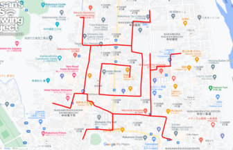
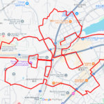
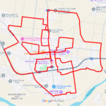
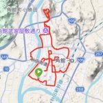
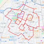
🌸 Castle Ruins and Waterside Blooms: A 7km Sakura Trail in Tsuboi 🌸
Located in the eastern part of Funabashi City, Chiba, the Tsuboi district is a captivating blend of modern residential planning and ancient heritage. The name “Tsuboi” is thought to derive from the topographical “hollows” (tsubo) of the Shimosa Plateau or from essential ancient wells (i). This 7km GPS art course invites you to celebrate the season by sketching a grand Sakura (cherry blossom) through this storied landscape.
The highlight of the route is Tsuboi Kinrin Park, a beloved local spot where cherry trees frame a picturesque pond. In spring, the water mirrors the pale pink petals, creating a tranquil atmosphere for your journey. As you trace the lines of the flower, you will pass through areas steeped in history, including the Tsuboi Castle Ruins—a medieval fortified residence—and the Nakaidai Ruins, which date back to the prehistoric Jomon period. It is a unique experience to run or walk over ground once inhabited by ancient settlers and samurai, all while using modern technology to create digital art.
Starting near the sleek Funabashi-Nichidai-Mae Station, the course leads you past the Tsuboi Community Center and through quiet, tree-lined streets. The terrain is relatively flat, making the 7km loop accessible for everyone from casual strollers to avid runners. By the time you complete your floral masterpiece on your smartphone, you will have connected with the geographical roots and cultural legacy of Funabashi. Lace up your shoes and breathe in the fresh spring air as you let your own creativity bloom in the historic heart of Tsuboi.
DETAIL (EXTERNAL LINK)

A PIONEER IN GPS ART.
1st work was authorized by Guinness World Records as “the Largest GPS Drawing”.
He is the only Japanese person to be featured in a Google documentary as an innovator. He is fascinated by the idea of drawing with GPS and has published more than 2,500 works.