Tokyo

Sort condition
Newest first
Oldest first
Large number of views
  1. 春の風公園のかえる(東京都練馬区)のGPSアート
    • TokyoKanto Region
    • 11 - 20km
    • Rainy SeasonSeason

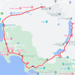
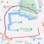
    Frog in Harunokaze Park, Nerima, Tokyo…

    GPS art for the rainy season, drawn in a park famous for its frog pond✨This is a course of frog GPS art to be drawn i…

  2. 高幡不動尊のかえる(東京都日野市)のGPSアート
    • TokyoKanto Region
    • 21 - 30km
    • Rainy SeasonSeason

    Snail in Takahata Fudoson, Hino, Tokyo…

    GPS art of snails drawn on a hydrangea spot✨This is a GPS artwork of a snail to be drawn on Takahata Fudozon, one of …

  3. ツーハンド-レッズ(百人町)のGPSアート
    • TokyoKanto Region
    • 11 - 20km
    • LetterLetter/Symbol/Map

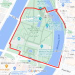
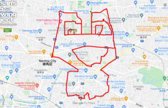
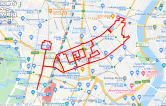
    Two Hand-Reds in Hyakunin-cho 12km

    200" GPS art to be drawn in Shinjuku Hyakunin-cho✨.✨This is a course of GPS art to be drawn in Shinjuku Hyakunin-cho.…

  4. 日本橋のこいのぼり(東京都中央区)のGPSアート
    • TokyoKanto Region
    • 11 - 20km
    • Children's DaySeason

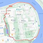
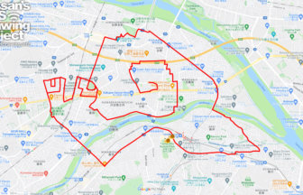
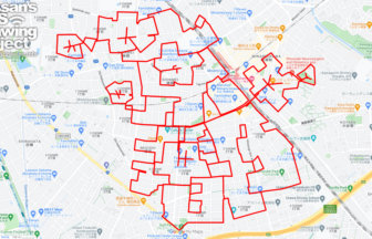
    Carp Streamer in Nihonbashi, Tokyo 11k…

    Koinobori GPS art in the middle of Tokyo✨This is a course of GPS art of Koinobori (carp streamers) to be drawn in Kab…

  5. 京都の春(埼玉県さいたま市)のGPSアート
    • TokyoKanto Region
    • 21 - 30km
    • PlantCherry BlossomSeasonAnimal/Plant

    Spring in Kyoto, Saitama pref. 23km

    Kyoto Marathon GPS Art Collection Awarded Cherry Blossom GPS Art✨This is the course of the Kyoto Marathon GPS Art Col…

  6. 上野公園のさくら(東京都台東区)のGPSアート
    • TokyoKanto Region
    • - 10km
    • Cherry BlossomSeason

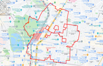
    Cherry Blossom in Ueno Park, Tokyo 10k…

    GPS art of cherry blossoms to be drawn at a nationally famous Cherry Blossom Viewing spot✨Known as a mecca for cherry…

  7. 西東京サークルウォーク(東京都西東京市)のGPSアート
    • TokyoKanto Region
    • 31km - 50km
    • SymbolCircle WalkOfficialLetter/Symbol/Map

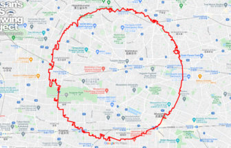
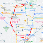
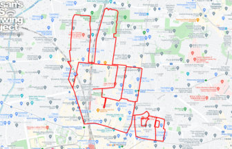
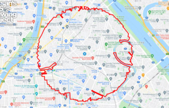
    NishiTokyo Circle Walk 35km

    Circle walk with a radius of 3.14 km drawn in "west" Tokyo✨This is a course plan for a very challenging GPS art event…

  8. 新宿サークルウォーク(東京都新宿区)のGPSアート
    • TokyoKanto Region
    • 31km - 50km
    • SymbolCircle WalkOfficialLetter/Symbol/Map

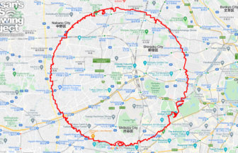
    Shinjuku Circle Walk 33km

    Circle walk with a radius of 3.14 km drawn around Shinjuku Metropolitan Government Building✨This is a course proposal…

  9. 向島サークルウォーク(東京都墨田区)のGPSアート
    • TokyoKanto Region
    • 11 - 20km
    • SymbolCircle WalkOfficialLetter/Symbol/Map

    Mukojima Circle Walk 19km

    Short distance, but lots of obstacles! Easy circle walk✨I've come up with the idea of a maniacal event called "Circle…

  10. 猫坂の猫(東京都文京区)のGPSアート
    • TokyoKanto Region
    • - 10km
    • AnimalAnimal/Plant

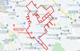
    Cat in Nekomata-zaka Slope, Bunkyo, To…

    GPS art of a cat, drawing on cat place names✨February 22 is Cat Day. This is a course on drawing art in places associ…

  1. C(香川県直島町)のGPSアート

    “C” in Naoshima, Kagawa pref. 4km

  2. C(長野県長野市)のGPSアート

    “C” in Nagano City 5km

  3. C(東京都北区)のGPSアート

    “C” in Kita ward, Tokyo 1km

  4. C(広島県広島市)のGPSアート

    “C” in Hiroshima City 1km

  5. C(愛知県名古屋市)のGPSアート

    “C” in Nagoya, Aichi pref. 3km

  1. 東京スカイツリーに描くこいのぼりのGPSアート

    Carp Streamer in around Tokyo Skytree 4km

  2. Douglas MacArthur in around Yokota Base 33km

  3. ミャクミャク様(大阪市)のGPSアート

    Myaku-Myaku in Osaka 41km

  4. ピースマーク(千葉県船橋市)のお絵かきラン

    PEACE on Finabashi, Chiba pref. 4km

  5. TokyoCircleWalk

    Tokyo Circle Walk 32km

ARCHIVES