Tokyo

Sort condition
Newest first
Oldest first
Large number of views
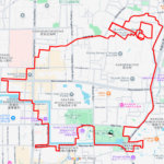
  1. 神代植物公園のカタツムリ(東京都調布市)のGPSアート
    • Kanto RegionTokyo
    • 11 - 20 km
    • AnimalAnimal/PlantRainy SeasonSeason

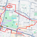
    Snail in Jindai Botanical Gardens, Cho…

    GPS art route traces the shape of a snail through the lush surroundings of Jindai Botanical Garden and its neighborin…

  2. 多摩川台公園のカタツムリ(東京都大田区)のGPSアート
    • Kanto RegionTokyo
    • - 10 km
    • AnimalAnimal/PlantRainy SeasonSeason

    Snail in Tamagawadai Park, Ota, Tokyo …

    GPS art course in the shape of a snail through Tamagawadai Park, nestled along the banks of the Tama River.

    • Kanto RegionTokyo
    • - 10 km
    • AnimalAnimal/PlantRainy SeasonSeason

    Snail in Shibakawa Watergate, Adachi, …

    Snail GPS art around the Shibakawa Floodgate, on the border between Tokyo and Saitama.

  3. 府中市郷土の森博物館のカタツムリ(東京都府中市)のGPSアート
    • Kanto RegionTokyo
    • - 10 km
    • AnimalAnimal/PlantRainy SeasonSeason

    Snail in Kyodo No Mori Historical Muse…

    Enjoying Early Summer Strolls in Kyodo no Mori, an open-air museum nestled on the river terrace.

  4. 飛鳥山公園のカタツムリ(東京都北区)のGPSアート
    • Kanto RegionTokyo
    • - 10 km
    • AnimalAnimal/PlantRainy SeasonSeason

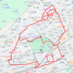
    Snail in Asukayama Park, Kita Ward, To…

    GPS art of a snail in a historic urban park beloved since the Edo period.

  5. 多摩湖の"C"(東京都東大和市)のGPSアート
    • Kanto RegionTokyo
    • - 10 km
    • LetterLetter/Symbol/MapOfficialWalk in Her Shoes

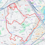
    “C” in Tama Lake, Higashiy…

    "C"-Shaped GPS Art in nature around Lake Tama, an artificial lake created during the Taisho era.

  6. 代々木公園の"C"(東京都渋谷区)のGPSアート
    • Kanto RegionTokyo
    • - 10 km
    • LetterLetter/Symbol/MapOfficialWalk in Her Shoes

    “C” in Yoyogi Park, Shibuy…

    C-shaped GPS Art in the Urban Oasis of Yoyogi Park, a sprawling green space that provides a peaceful escape from the …

  7. 石神井池の"C"(東京都練馬区)のGPSアート
    • Kanto RegionTokyo
    • - 10 km
    • LetterLetter/Symbol/MapOfficialWalk in Her Shoes

    “C” in Shakujii Pond, Neri…

    GPS art on Shakujii Pond in Nerima-ward, a waterfront space located in the center of Shakujii Park.

  8. 三宝寺池の"C"(東京都練馬区)のGPSアート
    • Kanto RegionTokyo
    • - 10 km
    • LetterLetter/Symbol/MapOfficialWalk in Her Shoes

    “C” in Sanpōji Pond, Nerim…

    GPS art on Sanpoji Pond, a natural pond with a long history that has been nurtured by the abundant underground water …

  9. 等々力渓谷公園の"C"(東京都世田谷区)のGPSアート
    • Kanto RegionTokyo
    • - 10 km
    • LetterLetter/Symbol/MapOfficialWalk in Her Shoes

    “C” in Todoroki Ravine Par…

    GPS art in Todoroki Ravine Park in Setagaya Ward, known as the only ravine in the 23 wards of Tokyo.

  1. 平和市民公園のさくら(大分県大分市)のGPSアート

    Cherry Blossom in Heiwa City Park, Oita City 11km

  2. 桐生が岡動物園のさくら(群馬県桐生市)のGPSアート

    Cherry Blossom around Kiryugaoka Zoo, Kiryu, Gunm…

  3. 糸川遊歩道のさくら(静岡県熱海市)のGPSアート

    Cherry Blossom around Itokawa Promenade, Atami, S…

  4. 稲荷公園のさくら(愛知県一宮市)のGPSアート

    Cherry Blossom around Inari Park, Ichinomiya, Aic…

  5. 坪井近隣公園のさくら(千葉県船橋市)のGPSアート

    Cherry Blossom around Tsuboi Kinrin Park, Funabas…

  1. 夢洲サークルウォーク(大阪市此花区)のGPSアート

    Yumeshima Circle Walk 2km

  2. TokyoCircleWalk

    Tokyo Circle Walk 32km

  3. 上野公園のさくら(東京都台東区)のGPSアート

    Cherry Blossom in Ueno Park, Tokyo 10km

  4. Treasure Ship Tour of the Seven Lucky Gods (10 km…

  5. ミャクミャク様(大阪市)のGPSアート

    Myaku-Myaku in Osaka 41km

ARCHIVES