Letter/Symbol/Map

Sort condition
Newest first
Oldest first
Large number of views
  1. 大仙公園の"C"(大阪府堺市堺区)のGPSアート
    • Kinki RegionOsaka
    • - 10 km
    • LetterLetter/Symbol/MapOfficialWalk in Her Shoes

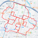
    “C” in Daisen Park, Sakai …

    C-shaped GPS art in Daisen Park overlooking a world heritage site.

  2. 桃ヶ池公園の"C"(大阪市阿倍野区)のGPSアート
    • Kinki RegionOsaka
    • - 10 km
    • LetterLetter/Symbol/MapOfficialWalk in Her Shoes

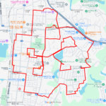
    “C” in Momogaike Park, Abe…

    GPS art in Momogaike Park in Abeno Ward, Osaka City, creating a space where sports and nature coexist.

  3. 代々木公園の"C"(東京都渋谷区)のGPSアート
    • Kanto RegionTokyo
    • - 10 km
    • LetterLetter/Symbol/MapOfficialWalk in Her Shoes

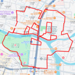
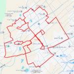
    “C” in Yoyogi Park, Shibuy…

    C-shaped GPS Art in the Urban Oasis of Yoyogi Park, a sprawling green space that provides a peaceful escape from the …

  4. 松本城の"C"(長野県松本市)のGPSアート
    • Chubu RegionNagano
    • - 10 km
    • LetterLetter/Symbol/MapOfficialWalk in Her Shoes

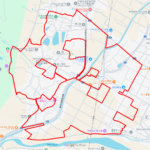
    “C” in Matsumoto-jō Castle…

    C-shaped GPS Art Along the Stone Walls of National Treasure Matsumoto Castle.

  5. 山中湖の"C"(山梨県山中湖村)のGPSアート
    • Chubu RegionYamanashi
    • - 10 km
    • LetterLetter/Symbol/MapOfficialWalk in Her Shoes

    “C” in Yamanakako Lake, Ya…

    Drawing a “C” of GPS Art in Yamanakako Lake, at the Foot of Mt. Fuji.

  6. 石神井池の"C"(東京都練馬区)のGPSアート
    • Kanto RegionTokyo
    • - 10 km
    • LetterLetter/Symbol/MapOfficialWalk in Her Shoes

    “C” in Shakujii Pond, Neri…

    GPS art on Shakujii Pond in Nerima-ward, a waterfront space located in the center of Shakujii Park.

  7. 三宝寺池の"C"(東京都練馬区)のGPSアート
    • Kanto RegionTokyo
    • - 10 km
    • LetterLetter/Symbol/MapOfficialWalk in Her Shoes

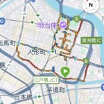
    “C” in Sanpōji Pond, Nerim…

    GPS art on Sanpoji Pond, a natural pond with a long history that has been nurtured by the abundant underground water …

  8. 等々力渓谷公園の"C"(東京都世田谷区)のGPSアート
    • Kanto RegionTokyo
    • - 10 km
    • LetterLetter/Symbol/MapOfficialWalk in Her Shoes

    “C” in Todoroki Ravine Par…

    GPS art in Todoroki Ravine Park in Setagaya Ward, known as the only ravine in the 23 wards of Tokyo.

  9. 三ツ池公園の"C"(神奈川県横浜市鶴見区)のGPSアート
    • KanagawaKanto Region
    • - 10 km
    • LetterLetter/Symbol/MapOfficialWalk in Her Shoes

    “C” in Mitsuike Park, Tsur…

    GPS art in Mitsuike Park in Tsurumi Ward, also known for its cherry blossoms.

  10. 碑文谷公園の"C"(東京都目黒区)のGPSアート
    • Kanto RegionTokyo
    • - 10 km
    • LetterLetter/Symbol/MapOfficialWalk in Her Shoes

    “C” in Himonya Pond, Megur…

    GPS art in Himonya Pond, once a natural pond fed by a spring and has been enjoyed by local residents for many years.

  1. ウインズ浅草の馬(東京都台東区)のGPSアート

    Horse around JRA Wins Asakusa, Taito, Tokyo 9km

  2. ウインズ銀座の馬(東京都中央区)のGPSアート

    Horse around JRA Wins Ginza, Chuo, Tokyo 10km

  3. ウインズ津軽の馬(青森県田舎館村)のGPSアート

    Horse around JRA Wins Tsugaru, Inakadate, Aomori …

  4. ウインズ立川の馬(東京都立川市)のGPSアート

    Horse around JRA Wins Tachikawa,Tachikawa, Tokyo …

  5. ウインズ札幌の馬(北海道札幌市中央区)のGPSアート

    Horse around JRA Wins Sapporo, Sapporo, Hokkaido …

  1. E.T. flying through the sky, Kita Akita, Akita Pr…

  2. Douglas MacArthur in around Yokota Base 33km

  3. Aomori-Hakodate Ferry, Aomori, Aomori Pref. 11km

  4. Cherry Blossom in Osaka Castle 9km

  5.  Trotting horse #2026 (Akita City, Akita Prefectu…

ARCHIVES