Kanto Region

Sort condition
Newest first
Oldest first
Large number of views
  1. 青山霊園のおばけ(東京都港区)のGPSアート
    • Kanto RegionTokyo
    • 11 - 20 km
    • HalloweenSeason

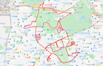
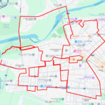
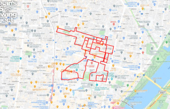
    Ghost in Aoyama Cemetery 14km

    GPS art of ghosts drawn in one of Tokyo's largest public cemeteries✨The Aoyama Cemetery is a large public cemetery l…

  2. 四谷のお岩さん(東京都新宿区)のGPSアート
    • Kanto RegionTokyo
    • - 10 km
    • HalloweenSeason

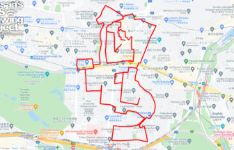
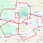
    Ghost of Oiwa in Yotsuya 9km

    Oiwa-san" drawn in the town of Yotsuya Kaidan✨This is a course of GPS art of Oiwa-san, drawn in Zoshigaya Yotsuya-ch…

  3. 醤(千葉県野田市)のGPSアート
    • ChibaKanto Region
    • 21 - 30 km
    • LetterLetter/Symbol/Map

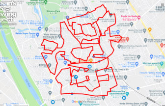
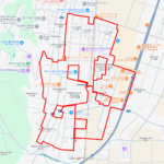
    Soy Sauce in Noda 25km

    The character for "soy sauce" drawn in the town of soy sauce✨Noda is the largest producer of soy sauce in Japan, pro…

  4. ドムドムバーガーのリック・ドム(東京都浅草)のGPSアート
    • Kanto RegionTokyo
    • - 10 km
    • CharacterPeople/Character

    RICK DOM @Dom Dom Burger in Asakusa, T…

    Rick Dom drawing on Dom Dom✨Dom Dom Burger, Japan's first hamburger chain, opened a new restaurant in Asakusa Hanaya…

  5. 船橋サークルウォーク(千葉県船橋市)のGPSアート
    • ChibaKanto Region
    • - 10 km
    • Circle WalkLetter/Symbol/MapOfficialSymbol

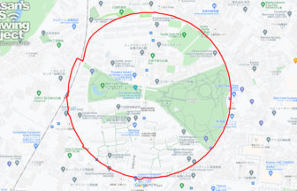
    Funabashi Circle Walk 2.6km

    A circle drawn on the site of a wireless telegraph station✨The Funabashi Transmitting Station of the Naval Wireless …

  6. 柏サークルウォーク(千葉県柏市)のGPSアート
    • ChibaKanto Region
    • 31 - 50 km
    • Circle WalkLetter/Symbol/MapOfficialSymbol

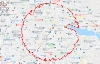
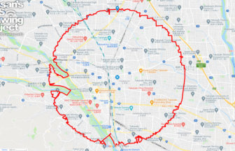
    Kashiwa Circle Walk 36km

    A circle with a radius of 3.14 km to be drawn around CHI-BA+KUN's nose✨Chiba Prefecture's official character "Chii-b…

  7. 水戸サークルウォーク(茨城県水戸市)のGPSアート
    • IbarakiKanto Region
    • 31 - 50 km
    • Circle WalkLetter/Symbol/MapOfficialSymbol

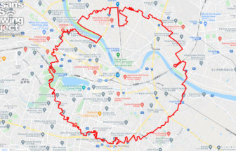
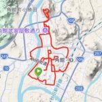
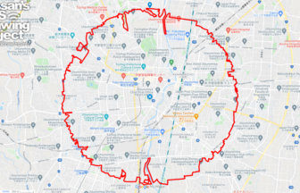
    Mito Circle Walk 43km

    A circle with a radius of 3.14 km drawn around Mito Castle✨Mito Castle was once home to one of the three Tokugawa fa…

  8. 高崎サークルウォーク(群馬県高崎市)のGPSアート
    • GunmaKanto Region
    • 31 - 50 km
    • Circle WalkLetter/Symbol/MapOfficialSymbol

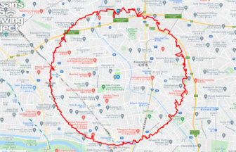
    Takasaki Circle Walk 35km

    A circle with a radius of 3.14 km drawn at the gateway to the northern Kanto region✨Takasaki City is a major city in…

  9. Utsunomiya Circle Walk
    • Kanto RegionTochigi
    • 31 - 50 km
    • Circle WalkLetter/Symbol/MapOfficialSymbol

    Utsunomiya Circle Walk 40km

    A circle with a radius of 3.14 km drawn around the Utsunomiya castle ruins✨Utsunomiya City, an ordinance-designated …

  10. 川口サークルウォーク(埼玉県川口市)のGPSアート
    • Kanto RegionSaitama
    • 31 - 50 km
    • Circle WalkLetter/Symbol/MapOfficialSymbol

    Kawaguchi Circle Walk 33km

    A circle course with a radius of 3.14 km drawn in the center of Kawaguchi culture✨Kawaguchi is a bedroom community t…

  1. 江戸川区自然動物園のライチョウ(東京都江戸川区)のGPSアート

    Rock Ptarmigan in Edogawa City Nature Zoo, Edogaw…

  2. さらんべ公園のさくら(北海道八雲町)のGPSアート

    Cherry Blossom around Saranbe Park, Yakumo, Hokka…

  3. 猿賀公園のさくら(青森県平川市)のGPSアート

    Cherry Blossom around Saruka Park, Hirakawa, Aomo…

  4. お物見公園のさくら(岩手県奥州市)のGPSアート

    Cherry Blossom around Omonomi Park, Oshu, Iwate p…

  5. 鹽竈神社のさくら(宮城県塩竈市)のGPSアート

    Cherry Blossom around Shiogama Shrine, Shiogama, …

  1. Around the World in Osaka 20km

  2. 上野公園のさくら(東京都台東区)のGPSアート

    Cherry Blossom in Ueno Park, Tokyo 10km

  3. Aomori-Hakodate Ferry, Aomori, Aomori Pref. 11km

  4. Nazca-style spider, Kita Akita, Akita Pref. 7.7km

  5. Mount Kojō and the Cherry Blossoms of Kakunodate …

ARCHIVES