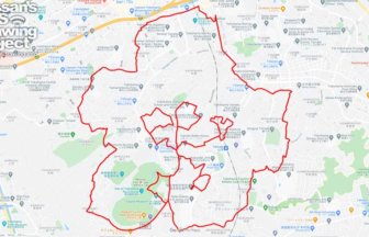
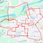
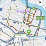
“C”-Shaped GPS Art in nature around Lake Tama✨
International cooperation by GPS art of “C” onto Tama Lake! From March 8 (Saturday) to May 31 (Saturday), 2025, a new project of “Walk in Her Shoes 2025”, “Let’s Walk and Draw “C” on the Earth! Let’s start GPS art!
Walk in Her Shoes 2025″ is an international cooperation program to raise awareness about global water issues and the current situation of women and girls in developing countries by simply walking at a time and place of your choice. Let’s draw the “C” of CARE with GPS art and send it to the world!
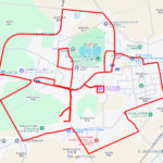
Tama Lake (officially called the Murayama Reservoir) is an artificial lake created during the Taisho era as a vital water source for Tokyo, and it continues to serve the city’s water needs today. The lake is surrounded by the Sayama Hills on the west, including Sayama Park, which offers well-maintained trails and lush greenery. Known as a cherry blossom viewing spot in spring, the area provides a peaceful, nature-rich escape from the bustling metropolis.
This GPS art route traces a “C” shape along the eastern shore of Tama Lake. Walkers can enjoy scenic views from elevated paths, observe historical waterworks facilities, and experience a blend of urban infrastructure and natural beauty that is unique to the Tama region.
This year, by walking or running and leaving a trail of the “C” of CARE and posting the saved GPS image on Facebook, X (Twitter), and Instagram with the two hashtags “#Walking for InternationalCooperation2025” and “#GPSArt,” you can donate 100 yen.
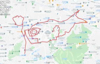
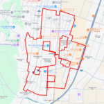
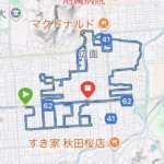
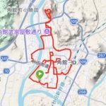
We are also developing a Walk in Her Shoes 2025 version of the “Reply Art” developed by the “Hokuriku GPS Art Club”. Please try this one as well!
Detail of “Reply Art”
https://hokuriku-gpsart.com/wp-content/uploads/2025/04/2cb6a57db96336b840ba94646e4d42ba.pdf
Reference: Walk in Her Shoes
https://www.careintjp.org/walk_in_her_shoes/index.html

DETAIL (EXTERNAL LINK)

A PIONEER IN GPS ART.
1st work was authorized by Guinness World Records as “the Largest GPS Drawing”.
He is the only Japanese person to be featured in a Google documentary as an innovator. He is fascinated by the idea of drawing with GPS and has published more than 2,500 works.