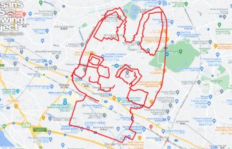
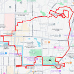
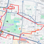
GPS art of the place name “Tama” drawn in Tama Ward✨
This is a series of GPS art courses that draw the place name “Tama” in Tama Ward, Kawasaki.
Tama Ward was created in 1972 when Kawasaki City became an ordinance-designated city. It is located between the Tama River to the north and the Tama Hills to the south. It is often confused with the Tama district of Tokyo, but it seems that the boundaries kept changing due to repeated changes in the flow path of the Tama River in what was originally the same area. It is complicated.
This work depicts a residential area along the Tama River, moving from one place to another. I think you will be able to feel the people who live with the Tama River.

Source: Wikimedia Commons
DETAIL (EXTERNAL LINK)

A PIONEER IN GPS ART.
1st work was authorized by Guinness World Records as “the Largest GPS Drawing”.
He is the only Japanese person to be featured in a Google documentary as an innovator. He is fascinated by the idea of drawing with GPS and has published more than 2,500 works.