Official

Sort condition
Newest first
Oldest first
Large number of views
  1. 日比谷公園の"C"(東京都千代田区)のGPSアート
    • Kanto RegionTokyo
    • - 10 km
    • LetterLetter/Symbol/MapOfficialWalk in Her Shoes

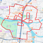
    “C” in Hibiya Park, Chiyod…

    GPS art in Hibiya Park, opened in 1903 as Japan's first Western-style modern urban park.

  2. 舎人公園の"C"(東京都足立区)のGPSアート
    • Kanto RegionTokyo
    • - 10 km
    • LetterLetter/Symbol/MapOfficialWalk in Her Shoes

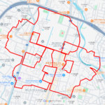
    “C” in Toneri Park, Adachi…

    GPS art in Toneri Park, a popular recreational area in Adachi-ward, Tokyo.

  3. 桑袋ビオトープ公園の"C"(東京都足立区)のGPSアート
    • Kanto RegionTokyo
    • - 10 km
    • LetterLetter/Symbol/MapOfficialWalk in Her Shoes

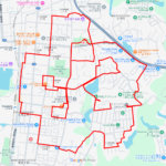
    “C” in Kuwabukuro Biotope …

    GPS art in Kuwabukuro Biotope Park, located in the northeast corner of Adachi-ward, Tokyo.

  4. 熱田神宮の"C"(愛知県名古屋市熱田区)のGPSアート
    • AichiChubu Region
    • - 10 km
    • LetterLetter/Symbol/MapOfficialWalk in Her Shoes

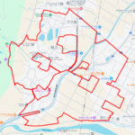
    “C” in Atsuta-jingu, Nagoy…

    GPS art at Atsuta Jingu (Atsuta Shrine) in Atsuta-ward, Nagoya City, Aichi Pref.

  5. 別所沼の"C"(さいたま市南区)のGPSアート
    • Kanto RegionSaitama
    • - 10 km
    • LetterLetter/Symbol/MapOfficialWalk in Her Shoes

    “C” in Bessho-numa Park, S…

    GPS art in Bessho-numa Park (Bessho-numa Swamp) in Minami-ku, Saitama City.

  6. 南芦屋浜の"C"(兵庫県芦屋市)のGPSアート
    • HyogoKinki Region
    • - 10 km
    • LetterLetter/Symbol/MapOfficialWalk in Her Shoes

    “C” in Minami-Ashiyahama, …

    GPS art on Minami Ashiya-hama island, an artificial island in Ashiya City, Hyogo Pref.

  7. 新夕陽ヶ丘の"C"(大阪市此花区)のGPSアート
    • Kinki RegionOsaka
    • - 10 km
    • LetterLetter/Symbol/MapOfficialWalk in Her Shoes

    “C” in New Sunset Hill, Os…

    GPS art on New Sunset Hill (Shin Yuhigaoka) in Maishima island, Konohana-ward, Osaka.

  8. 水元公園、みさと公園の"C"(東京都葛飾区)のGPSアート
    • Kanto RegionSaitamaTokyo
    • - 10 km
    • LetterLetter/Symbol/MapOfficialWalk in Her Shoes

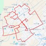
    “C” in Mizumoto Park and M…

    GPS art can be drawn between Mizumoto Park in Katsushika-ward, Tokyo and Misato Park in Misato City, Saitama Prefectu…

  9. 旧中川水辺公園の"C”(東京都江戸川区)のGPSアート
    • Kanto RegionTokyo
    • - 10 km
    • LetterLetter/Symbol/MapOfficialWalk in Her Shoes

    “C” in Kyunaka River Water…

    GPS art that can be drawn by walking around the Old Nakagawa River Waterfront Park.

  10. 夢洲サークルウォーク(大阪市此花区)のGPSアート
    • Kinki RegionOsaka
    • - 10 km
    • Circle WalkLetter/Symbol/MapOfficialSymbol

    Yumeshima Circle Walk 2km

    GPS artwork to draw a 2km-long regular circle using the symbolic building, the O-roof ring, in the center of the Expo…

  1. ウインズ津軽の馬(青森県田舎館村)のGPSアート

    Horse around JRA Wins Tsugaru, Inakadate, Aomori …

  2. ウインズ立川の馬(東京都立川市)のGPSアート

    Horse around JRA Wins Tachikawa,Tachikawa, Tokyo …

  3. ウインズ札幌の馬(北海道札幌市中央区)のGPSアート

    Horse around JRA Wins Sapporo, Sapporo, Hokkaido …

  4. ウインズ後楽園の馬(東京都文京区)のGPSアート

    Horse around JRA Wins Korakuen, Tokyo 19km

  5. 小倉競馬場の馬(福岡県北九州市)のGPSアート

    Horse around Kokura Racecourse 18km

  1. The squid is the symbol of Hakodate🦑, Hokkaido, …

  2. Cherry Blossom in around Nago Castle Park 16km

  3. TokyoCircleWalk

    Tokyo Circle Walk 32km

  4. Cherry Blossom in Osaka Castle 9km

  5. Aomori-Hakodate Ferry, Aomori, Aomori Pref. 11km

ARCHIVES