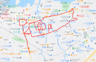
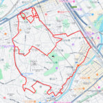
“Nagano” GPS Art: Tracing History from Zenkoji to the Castle Town Streets✨
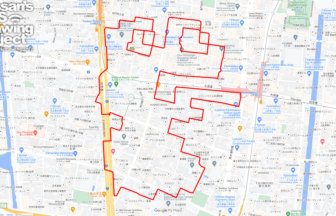
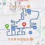
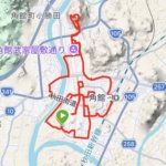
Centered around the iconic Zenkoji Temple, this 12km GPS art course takes you through Nagano’s historic heart, where tradition and modern life harmoniously converge. As you walk, the name “Nagano” appears on the map, formed by your footsteps across the city.
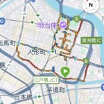
Starting at Zenkoji, the route passes through the lively Nakamise-dori, then follows Omotesando and Nagano Chuo-dori, where you’ll experience the atmosphere of a castle town blended with contemporary urban charm. The course also highlights the serene Nagano Prefectural Art Museum, before circling back to the vibrant Gondo Shopping Street—where the final strokes complete the characters “長野.” The moderate distance makes it ideal for both walkers and runners who wish to combine fitness with cultural exploration.
The name “Nagano” dates back to the Naga-no village in the ancient Minochi district, and is said to mean “long, gently sloping land.” Zenkoji Temple, founded in the 7th century, has long been a spiritual center, surviving wars and relocations of its sacred statue, once even moved under the protection of Takeda Shingen. Nakamise-dori flourished as a bustling temple town street serving pilgrims, while Omotesando was modernized in the Meiji era to connect Zenkoji with the station. The Prefectural Art Museum, with its architecture blending nature and light, represents Nagano’s modern cultural identity. Meanwhile, Gondo Shopping Street retains a nostalgic charm with its arcade, traditional machiya townhouses, and lively local shops.
This GPS art course offers more than a walk—it is an immersive way to experience Nagano’s layered history and culture. By tracing the city’s name, participants can feel the spirit of Zenkoji, the legacy of the castle town, and the vibrant everyday life of the locals.
TOURISTS SPOT
- Zenkōji Temple
- Sammon Gate, Zenkōji Temple
- Daihongan, Zenkōji Temple
- Saihōji Temple
- Zenkoji Omotesando
- Takei Shrine
- Nishinomiya Shrine
- Yubuku Shrine
- Nagano Prefectural Art Museum
- Higashiyama Kai Gallery, Nagano Prefectural Art Museum
- Gondo Shopping Street
- Zenkōji Nakamise Street
- Nagano City Hall
REFFERENCE

DETAIL (EXTERNAL LINK)

A PIONEER IN GPS ART.
1st work was authorized by Guinness World Records as “the Largest GPS Drawing”.
He is the only Japanese person to be featured in a Google documentary as an innovator. He is fascinated by the idea of drawing with GPS and has published more than 2,500 works.