🐦 Through Taisho Retro Architecture, Harbor Drawbridges, and Scenic Straits 🐦
Mojiko in Moji Ward, Kitakyushu City, Fukuoka Prefecture, occupies a storied location at the narrowest point of the Kanmon Straits separating Kyushu from Japan’s main island. Opening as an international trade port in 1889, the district flourished during the late 19th and early 20th centuries as a major shipping hub for coal and global commerce. Today, its remarkably preserved Taisho-era European architecture, red-brick warehouses, and scenic harborfront form “Mojiko Retro,” one of Japan’s most beloved nostalgic coastal destinations.
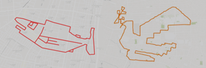
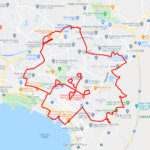
This gentle 5km GPS art course invites you to experience a storied harbor town, traversing historic promenades and iconic waterfront landmarks to sketch a Ptarmigan on your digital map.
The journey immerses you in rich maritime nostalgia, starting near the beautifully restored wooden Neo-Renaissance structure of Mojiko Station and the elegant Old Moji Mitsui Club, where Albert Einstein once stayed. Exploring the vibrant waterfront, you will cross the Blue Wing Moji pedestrian drawbridge, stroll past the shopping hub at Kaikyo Plaza, and visit cultural landmarks such as the Idemitsu Museum of Arts, Moji and the Moji Telecommunication Museum. The route guides you past the quiet green space of Oimatsu Park and the historic Koso Hachimangu Shrine, before taking in panoramic strait vistas beneath the soaring Mojiko Retro Observation Gallery in the heart of Mojiko Retro.
Featuring flat, breezy seaside pathways steeped in Taisho-era romanticism, this 5km route offers an accessible and memorable harbor walk. As the digital silhouette completes on your map, you are left with an unforgettable impression of this historic strait portal.
RESTAURANTS

DETAIL (EXTERNAL LINK)

A PIONEER IN GPS ART.
1st work was authorized by Guinness World Records as “the Largest GPS Drawing”.
He is the only Japanese person to be featured in a Google documentary as an innovator. He is fascinated by the idea of drawing with GPS and has published more than 2,500 works.