🐦 Through Scenic Lakefront Waters, Eco-Friendly Cities, and Historic Residences 🐦
Koshigaya Laketown, situated in eastern Saitama Prefecture, was developed around the monumental Ōsagami Retention Basin—a masterwork of modern flood control engineered in a low-lying river basin where the Motoarakawa and Naka Rivers meet. Today, this futuristic eco-city represents one of Japan’s most successful urban waterfront developments, harmonizing vast water retention lakes with AEON LakeTown, one of the nation’s largest sustainable commercial complexes. Beneath its modern waterfront charm lies rich feudal history, preserving Edo-period historic residences alongside peaceful neighborhood shrines.
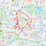
This 12km GPS art course invites you to experience a storied landscape, walking through scenic lakefront promenades and historic sites to sketch a Ptarmigan on your digital map.
The journey immerses you in a serene aquatic atmosphere, starting near the sweeping waters of the Ōsagami Retention Basin (Sakura Lake) and the adjoining Ōsagami Retention South Basin. Navigating vibrant lakefront arcades, you will pass AEON LakeTown OUTLET, AEON LAKE TOWN MORI, and the modern transit portal at Koshigaya-Laketown Station. Exploring local heritage, the path leads to the thatched-roof architecture of the Old Higashikata Nakamura’s House—a preserved Edo-period village headman’s estate—and the peaceful grounds of Hie Shrine Shrine / Tenman Tenjinsha Shrine.
Featuring flat, beautifully paved waterfront trails and spacious avenues, this 12km route captures Koshigaya’s forward-looking spirit. As the digital silhouette completes on your map, you are left with a memorable impression of this eco-friendly lakefront town.
RESTAURANTS

DETAIL (EXTERNAL LINK)

A PIONEER IN GPS ART.
1st work was authorized by Guinness World Records as “the Largest GPS Drawing”.
He is the only Japanese person to be featured in a Google documentary as an innovator. He is fascinated by the idea of drawing with GPS and has published more than 2,500 works.