🐦 Through Red-Brick Industrial Heritage and Historic Railway Depots 🐦
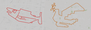
Higashi and Chuo Wards in Sapporo City, Hokkaido, represent the heart of the region’s Meiji-era development (Kaitakushi), serving as the cradle of Japan’s early northern industries and railway expansion. The Naebo district in particular is celebrated for its remarkably preserved red-brick architecture, former breweries, and rail maintenance yards. This heritage seamlessly integrates with modern urban life, creating a unique historical tapestry against Sapporo’s characteristic gridiron streets. This 13km GPS art course invites you to experience a storied landscape, weaving through industrial heritage sites and leafy parks to sketch a Ptarmigan on your digital map.
The journey immerses you in rich northern history, starting near the iconic red-brick facade of the Sapporo Beer Museum and the vibrant shopping complex at Sapporo Factory, built on the site of Japan’s first commercial brewery. Exploring the historic rail corridor, you will encounter the Hokkaido Railway Technology Museum, the historic Naebo Station, and the soothing thermal waters of Naebo Station Onsen Kura no Yu. The path guides you past tranquil green retreats such as Nagayama Memorial Park, Fushiko Park, and Kibo Park, while connecting with the energetic hub surrounding Sapporo Station.
Featuring flat, open avenues full of industrial heritage, this 13km route captures Sapporo’s pioneering spirit. As the digital silhouette completes on your map, you are left with a memorable impression of Hokkaido’s historic capital.
RESTAURANTS

DETAIL (EXTERNAL LINK)

A PIONEER IN GPS ART.
1st work was authorized by Guinness World Records as “the Largest GPS Drawing”.
He is the only Japanese person to be featured in a Google documentary as an innovator. He is fascinated by the idea of drawing with GPS and has published more than 2,500 works.