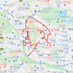
🐦 Through Iconic Clock Towers, Vibrant Greenways, and Red-Brick Landmarks 🐦
Chuo Ward in Sapporo City, Hokkaido, stands as the administrative, economic, and cultural heart of northern Japan. Laid out under a master grid plan by the Meiji-era Development Commission (Kaitakushi), the district is defined by wide, orderly avenues and the lush green expanse of Odori Park bisecting the downtown core. Seamlessly integrating historic red-brick landmarks with vibrant modern shopping and entertainment districts, the area offers a captivating urban environment.
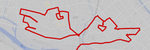
This 13km GPS art course invites you to experience a storied landscape, weaving through Sapporo’s most iconic central sites to sketch a Ptarmigan on your digital map.
The journey immerses you in rich northern heritage, starting near the modern transportation hub at Sapporo Station and the sky-high vistas of JR Tower Observatory T38. Tracing historical routes, you will discover the brewing and sake traditions at Sapporo Beer Museum and Chitosetsuru Sake Museum, alongside the serene lawns of Nagayama Memorial Park. The path guides you past the pioneer-era heritage of the Hokkaido University Museum in Botanic Garden, the grand Hokkaido Aka Renga (Red Brick Building), and the famous Sapporo Clock Tower. Moving toward the cultural hub at Sapporo Cultural Arts Theater hitaru, the route explores the soaring Sapporo TV Tower and the verdant paths of Odori Park.
Featuring flat, gridiron avenues connecting historic architecture with dynamic urban spaces, this 13km route captures Sapporo’s timeless allure. As the digital silhouette completes on your map, you are left with a memorable impression of Hokkaido’s metropolis.
TOURISTS SPOT
- Odori Park
- Nagayama Memorial Park
- JR Tower Observatory T38
- Miyoshi Shrine
- Sapporo Beer Museum
- Chitosetsuru Sake Museum
- Hokkaido University Museum in Botanic Garden
- Hokkaido Aka Renga (Red Brick Building)
- Sapporo Clock Tower
- Sapporo TV Tower
- Sapporo Cultural Arts Theater
- Sapporo Station
- Susukino Station
RESTAURANTS
- Chinese Hotei
- Nemuro Hanamaru Daido Seimei Sapporo Building miredo
- Soup Curry Okushiba Store Ekimae Soseiji
- Ganso Ramen Yokocho Sapporo
- Yukikaze
- Ramen Shingen minami 6 jo branch
REFFERENCE
- GPS ART Courses in ChuoWard, Sapporo City, Hokkaido Island
- GPS ART Courses in Sapporo City, Hokkaido Island
- How to make GPS Art

DETAIL (EXTERNAL LINK)

A PIONEER IN GPS ART.
1st work was authorized by Guinness World Records as “the Largest GPS Drawing”.
He is the only Japanese person to be featured in a Google documentary as an innovator. He is fascinated by the idea of drawing with GPS and has published more than 2,500 works.