🐦 Through Scenic Suwa Lakefronts, Alpine Views, and Historic Cultural Centers 🐦
Shimosuwa Town, situated along the northern shores of Lake Suwa in central Nagano Prefecture, holds a unique place in history as the only post town where two major Edo-period highways—the Nakasendo and Koshukaido—intersected. Nestled 759 meters above sea level against dramatic alpine backdrops, the district is celebrated for its ancient Suwa Taisha shrines, soothing thermal hot springs, and rich artistic heritage along the waterfront.
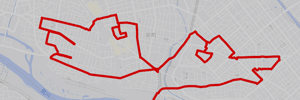
This 8km GPS art course invites you to experience a storied landscape, walking through serene lakefront promenades and historic cultural sites to sketch a Ptarmigan on your digital map.
The journey immerses you in refreshing lakefront charm, starting near Shimo-Suwa Station and the civic hub at Shimosuwa Cultural Center. Reaching the scenic shore of Lake Suwa, you will pass the elegant Harmo Museum, renowned for its naive art collection featuring Henri Rousseau. The route guides you past Shimosuwa Kohama, designated among the Kanto’s 100 Best Views of Mt. Fuji, where iconic views of Mount Fuji unfold across the shimmering water on clear days.
Featuring flat, scenic waterside paths wrapped in fresh alpine air and historic post-town heritage, this 8km route offers an unforgettable lakeside stroll. As the digital silhouette completes on your map, you are left with a memorable impression of Shinshu’s scenic heartland.
RESTAURANTS
REFFERENCE

DETAIL (EXTERNAL LINK)

A PIONEER IN GPS ART.
1st work was authorized by Guinness World Records as “the Largest GPS Drawing”.
He is the only Japanese person to be featured in a Google documentary as an innovator. He is fascinated by the idea of drawing with GPS and has published more than 2,500 works.